
| Method | Copper engraved with hand colour |
| Artist | Ortelius, Abraham |
| Published | Cum Privilegio ad decennium [1584] |
| Dimensions | 347 x 460 mm |
| Notes |
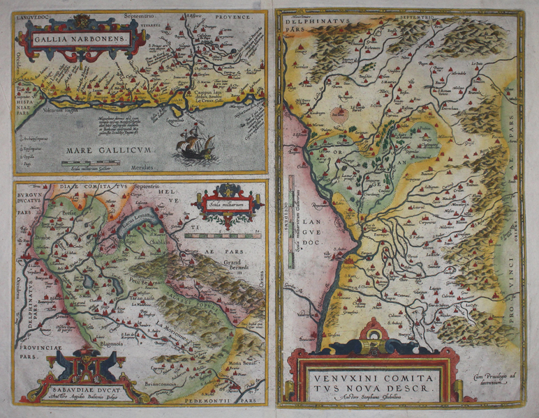
A double-page with three maps, from the 1584 German edition of Ortelius' 'Theatrum Orbis Terrarum'. Rivers, hills and forests have been included in lovely detail, and notable towns have been picked out in red. Maps covers the Rhône River from Switzerland to the Mediterranean Sea. The upper left maps the coast of the Mediterranean Sea (towns include Narbonne, Aigues Mortes, Avignon, Arles). The bottom left corner map illustrates the area between the lake of Geneva and Grenoble, with the French and Italian Alps. The full page map on the right shows the area of the Provence with in the centre Orange. Title to each map included in a decorative strapwork cartouche. With German text to verso. Abraham Ortelius (1527 -1598) was a Flemish cartographer, cosmographer, geographer and publisher and a contemporary of Gerard Mercator, with whom he travelled through Italy and France. Although it is Mercator who first used the word "Atlas" as a name for a collection of maps, it is Ortelius who is remembered as the creator of the first modern atlas. 'Theatrum Orbis Terrarum' was the first systematically collated set of maps by different map makers in a uniform format. Three Latin editions as well as a Dutch, French and German edition of 'Theatrum Orbis Terrarum' were published by 1572 and a further 25 editions printed before Ortelius' death in 1598. Several more were subsequently printed until around 1612. Ortelius is said to have been the first person to pose the question of the continents once being a single land mass before separating into their current positions. Condition: Tear repairs to lower margin. Surface dirt and time toning. Printers crease to top left corner. Central vertical fold, as issued. |
| Framing | unmounted |
| Price | £250.00 |
| Stock ID | 45539 |