
| Method | Copper engraved with original hand colour |
| Artist | Kitchin, Thomas |
| Published | By Thos. Kitchin, Hydrographer to the King. London. Published by Laurie & Whittle, No. 53, Fleet Street, 12th May 1794 |
| Dimensions | 1010 x 1230 mm |
| Notes |
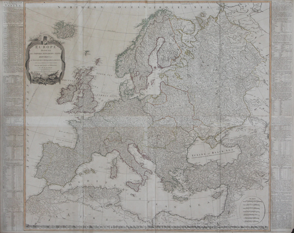
A monumental wall map of Europe, compiled by Thomas Kitchen from the surveys of d'Anville, and printed over four sheets by Laurie & Whittle for Kitchin's General Atlas, describing the Whole Universe: being a complete collection of the most approved maps extant; corrected with the greatest care, and augmented from the last edition of D'Anville and Robert with many improvements by other eminent geographers. The map, impressive in its scale, covers the entire European continent, from Ireland in the West to the Asian steppes in the East, and from North Africa in the South to the Arctic Circle in the North. Borders and sea coasts are outlined in hand colour, and each country is thoroughly and meticulously detailed, with cities, towns, and villages individually plotted and labelled. To either side of the map, panels of explanatory text and cartographic notes discuss the size and composition of each European nation. Britain naturally finds favourable treatment, described by Kitchin as 'this happy Island, manned with the Sons of Liberty.' Along the bottom border of the map, across the top of North Africa, the flags and ensigns of the World's nations are depicted, featuring the various banners of the British Empire, as well as those of Barbary Pirates, the Emperor of China, the Papacy, and the newly established flag of the United States, showing here 13 stars representing the original 13 States of the Union. The map is further embellished by a simple oval cartouche in the bottom right corner containing various mile scales, as well as a large baroque title cartouche at top left, featuring emblems of the Arts and Sciences. Thomas Kitchin (1718-1784) was one of the best and most prolific engravers of the eighteenth-century. Born in Southwark, he was an apprentice of Emanuel Bowen in 1732. Based in Clerkenwell and later Holborn Hill, Kitchin worked as royal hydrographer to the king from 1773. He married Sarah Bowen, daughter of Emanuel, in 1739, and then Jane, daughter of Joseph Burroughs, in 1762. He is best known for The World From the Best Authorities published in Guthrie's New Geographical Grammar (1777), The Small English Atlas (1749) with Thomas Jefferys, and The Large English Atlas (1749 - 60) with Emanuel Bowen. Jean Baptiste Bourguignon d'Anville (11th July 1697 - 28th January 1782) was a French cartographer, geographer, and antiquarian, whose rigourous standards of geographic reference revolutionised map making during the latter half of the eighteenth century. Rather than rely on the authority of earlier cartographers in the creation of his maps, d'Anville insisted on verifiable evidence. The resulting maps looked vastly different from the work of his predecessors. Ornamentation was stripped back, and dubious locations were simply left blank. In 1754 he became a member of the Académie des Inscriptions et Belles Lettres, and in 1775 was appointed first geographer to King Louis XVI. Robert Laurie (c.1755-1836) was a British engraver, mezzotint artist, and publisher. In 1776, he was awarded a prize by the Society of Arts for the invention of a method of producing colour-printed mezzotints. Laurie succeeded the publisher Robert Sayer after the latter's death in 1794, and, in partnership with James Whittle, continued Sayer's prolific and well-established business on the Fleet Street, issuing prints, maps, illustrated books, charts, and nautical works. Following Laurie's retirement in 1812, Whittle continued in business with his former partner's son, Richard Holmes Laurie, who gained sole ownership of the business in 1818 with the death of Whittle. Condition: Printed over four sheets, folded and joined as issued. Original outline colour. Minor tears to folds. Minor time toning to edges of sheet, and to joins from previous mount. |
| Framing | unmounted |
| Price | £1,700.00 |
| Stock ID | 43629 |