
| Method | Copper engraved |
| Artist | Mercator, Gerard |
| Published | [Excudebat typis suis Isaacus Elzevirius, sumptibus Iudoci Hondii, Amsterdam, 1618] |
| Dimensions | 335 x 402 mm |
| Notes |
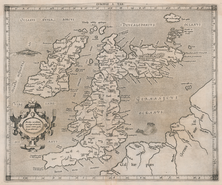
A finely engraved, decorative map of the British Isles, originally issued by Gerard Mercator for his edition of Ptolemy's Geographia. Mercator's Geographia retained the details of Ptolemy's ancient cartography but updated the plates with contemporary decorative elements. Scotland is shown with its distinctive Ptolemaic bend, resting at a severe right angle to a very elongated England and Wales. Hibernia (Ireland), which was much lesser known in the classical era, is also elongated. The various Celtic tribal and Roman administrative divisions of the British Isles are also marked, and principal Roman settlements are shown with their ancient names. In the bottom left, a strapwork cartouche reads: 'Maedius meridianus 20, reliqui ad eum inclinantur ratione 54 & 60 parallelorum.' Tabulae Geographicae Cl. Ptolemaei ad mentem autoris restitutae et emendatae, more commonly known as the Geographia, was intended by Mercator as the companion to his modern Atlas, providing the reader with the full measure of recent and historical geography. The maps, meticulously engraved and annotated by Mercator himself, are a curious blend of classical coastlines and contemporary cartographic conventions. Classical place names, peoples, and nations are retained, as are the ancient divisions of the Greco-Roman world of the second century AD, though these are overlaid with strapwork cartouches, sea monsters, increments of longitude and latitude, and the familiar symbols for towns, cities, forests, and mountain ranges. The atlas was initially published in 1578, reissued by Petrus Bertius in 1618 as part of his 'Theatrum Geographiae Veteris', before the plates were sold to François Halma, who reengraved the title cartouches for his 1695 Claudii Ptolemaei Tabulae Geographicae Orbis Terrarum Veteribus cogniti. After three editions by Halma, the plates, some badly worn and cracked, came into the possession of the Amsterdam-based publishers Wetstein and Smith, who published a final edition in 1730. This particular example is the 1618 printing from Petrus Bertius' 'Theatrum Geographiae Veteris.' Gerard Mercator (1512 - 1594) originally a student of philosophy was one of the most renowned cosmographers and geographers of the 16th century, as well as an accomplished scientific instrument maker. He is most famous for introducing Mercators Projection, a system which allowed navigators to plot the same constant compass bearing on a flat map. His first maps were published in 1537 (Palestine), and 1538 (a map of the world), although his main occupation at this time was globe-making. He later moved to Duisburg, in Germany, where he produced his outstanding wall maps of Europe and of Britain. In 1569 he published his masterpiece, the twenty-one-sheet map of the world, constructed on Mercator's projection. His Atlas, sive Cosmographicae Meditationes de Fabrica Mundi, was completed by his son Rumold and published in 1595. After Rumold's death in 1599, the plates for the atlas were published by Gerard Jr. Following his death in 1604, the printing stock was bought at auction by Jodocus Hondius, and re-issued well into the seventeenth century. Ptolemy (c. AD 100-170) was a Greek native of the Egyptian city of Alexandria, and a Roman citizen. Little is known about his life, but he is credited as the author of numerous works of mathematics, engineering, astronomy, astrology, philosophy, and geography. His most famous works were the Almagest, the Geography, and the Tetrabiblion, a triad that essentially formed the basis of Byzantine, Arabic, and European science for the next thousand years. The Geography in particular had a very long reach, being reprinted numerous times in the fifteenth and sixteenth centuries. Its most famous advocate was Columbus, who used a manuscript of the Geography to plot his western course for Asia, in the journey that resulted in the discovery of America. The work was also a major inspiration, and cartographic resource, for Munster, Mercator, and Ortelius. Shirley 123 Condition: Central vertical fold, as issued. Minor time toning to margins, otherwise an excellent clean impression. Latin text on verso. |
| Framing | unmounted |
| Price | £875.00 |
| Stock ID | 52008 |