
| Method | Copper engraved with original hand colour |
| Artist | Blaeu, Johannes |
| Published | c. 1646 |
| Dimensions | 415 x 525 mm |
| Notes |
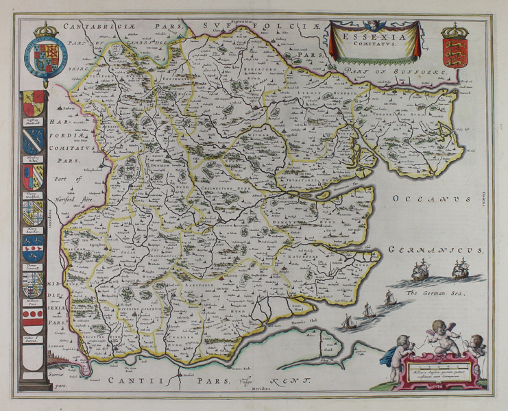
Blaeu's decorative map of the county of Essex, from volume four of the Atlas Major. The county Hundreds are outlined in hand colour, and the map is further embellished by a number of decorative cartouches enclosing the title, the Royal Arms, and a scale in English miles below a trio of putti carrying surveying tools. In the bottom left corner of the map, London is shown pictorially with Old St Paul's prominent, and in the waters of the Channel, numerous ships sail towards the Thames. Along the left hand border of the map, a run of shields blazon the crests of notable men of Essex. On the verso, a large diagram shows the burial chambers of a pair of barrows. Willem Blaeu founded the family business in 1596. It initially functioned as a globe and instrument makers, but soon expanded into maps, topography and sea charts. The acquisition of thirty-eight copper plates from the estate of Jodocus Hondius in 162 together with twenty-two of his own maps enabled Blaeu to produce his first atlas, the 'Atlas Appendix' in 1630. The Atlas Novus was Willems great work; a major work which intended to include the most up-to-date maps of the entire world. He issued the first two volumes in 1635, but died in 1638 before the atlas was completed. The running of the business was passed on to his sons Johannes and Cornelius, in addition to the role of the official cartographer of the East India Company. After the death of Cornelius in 1644, Johannes continued the business alone and established his own reputation as a great mapmaker. Johannes completed his father's grand project, culminating in 1658 in the production of the famous 'Atlas Major', regarded as one of the greatest achievements in the history of cartography. The county maps of England and Wales formed volume four of Blaeu's great atlas, this volume being first published in 1645. The Blaeu family were one of the most famous publishers of maps, globes and atlases during the seventeenth-century. Cartographers, globe makers and booksellers, the Blaeu business flourished in Amsterdam for over 40 years, until a fire destroyed their premises in 1672. They lost all of their plates, prints and stock, which effectively ruined the firm. Condition: Central vertical fold, as issued. Minor creasing to central fold. Minor time toning to edges of sheet. French text on verso. |
| Framing | mounted |
| Price | £500.00 |
| Stock ID | 12366 |