
| Method | Copper engraved |
| Artist | Godin, Henri-Joseph |
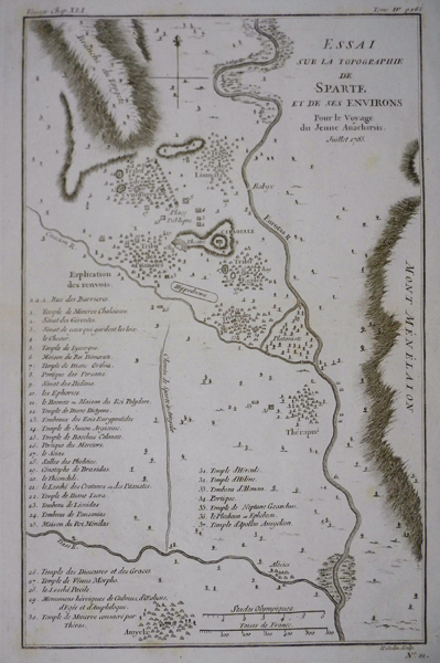
| Published | H. Godin Sculp. Juillet 1783 |
| Dimensions | 310 x 197 mm |
| Notes |
A plan of the Greek city-state of Sparta or Lacedaemon, and its environs, Plate 21 from the 1788 edition of Barbie du Bocage's Recueil de Cartes Geographiques Plans, Vues, et Medailles de l'Ancienne Grece, Reelatifs au Voyage du Jeune Anacharsis. The plan focusses on the cluster of settlements centred around the citadel of Sparta, a rocky spur on the banks of the Eurotas River, in the valley between the mountains of Taygetus and Parnon, here listed as Mont Menelaion, after the hero-shrine of the Mycenaean king of Lacedaemon, Menelaus. The nearby towns of Therapne and Amyclae are also depicted. The plan is extensively numbered, with a corresponding key of over thirty places of interest, including the temple of Artemis Orthia, the Gerousia, the council of the Ephors, the temple of Helen, and the tomb of Leonidas. Compared to other city-states, Sparta was unusual in its architecture and layout, as this plan ably shows. The historian Thucydides commented that an outsider, viewing the collection of villages that constituted Sparta, would never guess that this was the greatest military power in the Greek world. Sparta was the pre-eminent military power for much of the archaic and classical period of Greek history. Centred on the Eurotas Valley, the city-state differed in a number of significant ways from its contemporaries. Its system of government was a diarchy of two kings, supported by a council of elders. This system allowed one king to travel as the general of the Spartan army, while the other remained at home to govern. Spartan society was heavily focussed on military achievement, with young boys entering an intensive training program called the agoge at age seven. Women too were expected to undergo fitness training, upon the understanding that only strong mothers could bear strong children. Culturally, the Spartans were strongly resistant to outside influence, seeing the Athenian approach to wealth and luxury as decadent and dangerous to their way of life. The resulting tension between the two states eventually led to the Peloponnesian War, and despite Sparta's eventual victory, the losses sustained over thirty years of war irreparably weakened Spartan power. Their loss to Thebes in 371 BC at the Battle of Leuctra marked the end of Spartan hegemony in the Aegean. The Recueil de Cartes Geographiques Plans, Vues, et Medailles de l'Ancienne Grece, Reelatifs au Voyage du Jeune Anacharsis was an atlas published by the Paris booksellers, printmakers, and engravers Jean Denis Barbie du Bocage to accompany Jean-Jacques Barthelemy's Voyage du jeune Anacharsis en Grèce dans le milieu du IVe siècle. The Voyage du jeune Anacharsis was an unusual work. Written as a sort of general guidebook to the cities, customs, and culture of classical Greece, it purported to be the work of the grandson of the Scythian philosopher Anacharsis, documenting his travels in Greece during the 4th century BC. This clever literary conceit allowed the real author, Barthelemy, to explore the history and society of Classical Greece in a manner that was informative, yet informal, aiming to appeal to a much broader audience than a traditional academic history. Barthelemy was a talented antiquarian, particularly in regards to the study of ancient numismatics, and although the content of his work contains numerous historical flaws, the Voyage du jeune Anacharsis was a huge success, appearing in numerous editions and reprints. Sadly Barthelemy received very little from his success, his aristocratic background marking him as a target for the Revolutionary government, who confiscated most of his wealth. Despite his economic hardships, the general public continued to hold him in high esteem, and the demand for his material on ancient Greece was the main motivation behind the publication in 1788 of the accompanying Atlas to the Voyage. The first edition of Barbie's Recueil contained 31 plates related to Barthelemy's text, including maps of cities and territories, plans of battles, religious sanctuaries, and public spaces, and illustrations of temples, theatres, and even coins. Henri-Joseph Godin (1747-1834) was a French painter, engraver, and printmaker. He worked on maps for a number of atlases, as well as portraits, architectural plans, and antiquarian subjects. Condition: Central horizontal fold as issued. Minor time-toning to sheet. |
| Framing | unmounted |
| Price | £50.00 |
| Stock ID | 13260 |