
| Method | Copper engraved |
| Artist | Ortelius, Abraham |
| Published | Cum Imp. Reg. et Cancellariae Brabantiae privilegio decennali 1597 [Antwerp, 1624] |
| Dimensions | 360 x 462 mm |
| Notes |
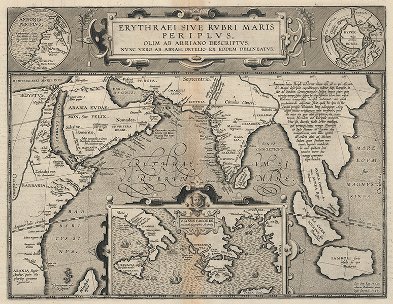
A fascinating map of the Red Sea and Indian Ocean, charting the text of the ancient Periplus of the Erythraean Sea, from the 1624 Latin Parergon (Supplement) of Ortelius' famous Theatrum Orbis Terrarum. The map stretches from the Eastern coast of Africa and the Arabian Peninsula, across Persia and the India Subcontinent, to the putative 'Aurea Regio,' or Kingdom of Gold in the Far East. Coasts and borders are hatchured in fine detail, and principal cities, towns, and trade ports of the period are plotted. The Greek text upon which the map is based was most likely composed in the first century AD by a Greco-Egyptian author, either based in Alexandria or the trading city of Berenice on the Red Sea Coast. The work, in sixty-six chapters, records a sailing voyage along the coasts of the Red Sea and India Ocean, beginning along the Egyptian and Arabian coasts, working down the African coast past Somalia to the trading port of Rhapta, often identified with a site just north of Dar-es-Salaam. From here, the author discusses the ports of the Arabian Peninsula, the Indo-Roman trading emporium of Barygaza, the cities and rulers of southern India, and finally the legacy of Alexander in the Greco-Bactrian kingdoms of Central Asia. The text also features what is considered to be one of the earliest western discussions of China, describing traders from a far off city called Thina. Some of the most interesting sites from the text here recorded are the trading port of Opone, just south of the horn of Africa and a site for trade for merchants from as far east as Indonesia and Malaysia, the city of Cana in Arabia, which is described as the key centre of trade in frankincense, and the southernmost tip of the Indian subcontinent, home to 'Piratae' who prey upon passing traders and attest to a very long history of piracy in the Indian Ocean. The island of Menuthesias, usually equated with Zanzibar, is shown here by Ortelius as Madagascar. The putative 'Land of Gold' to the very east of the map is here depicted in a manner reminiscent of the Indian Meridionalis or Dragons Tail so common on early sixteenth century maps of the Far East. The question of authorship of the Periplus, an ongoing discussion to this day, was also evidently of interest to Ortelius. Despite attributing the work to Arrian, author of a similar periplus of the Euxine (Black Sea), a large explanatory note east of the Ganges points out a number of problems with this attestation. Arrian's authorship of the Periplus has been largely rejected by scholars, and it is likely that the original attestation only came about through marginalia in a 10th century manuscript of the text, now in the collections of the University of Heidelberg. The map is further embellished by a number of decorative cartouches. The largest of these, occupying most of the Indian Ocean, is an inset map of the wanderings of Ulysses (Odysseus) in the Mediterranean, mapped by Ortelius himself from the Homeric epics. Ithaca is roughly equated with Corfu, and, like Ortelius' other mythographic maps, the south of Italy and Sicily are given as the locations for the Cyclopes, the monsters Scylla and Charybdis, the Sirens, the witch Circe, and the nymph Calypso. At the top of the map, the title cartouche is flanked by a pair of decorative roundels, each featuring an inset map. To the left, a section of map corresponding to the explorations of the Carthaginian Hanno on the Western coast of Africa is shown. Hanno's journey, undertaken at some point during the fifth or sixth century BC, was later written into a Periplus by an unknown Greek author. The extent of his journey is debated, with suggestions ranging anywhere from as far as Gabon to as near as Southern Morocco. On the opposite side, a map of the Arctic Regions erroneously shows a separate Polar island, named by Ortelius as Hyperborea, following classical conventions for the mythic land beyond the North Wind. The Parergon ('Supplement') was, as the title suggests, originally conceived of as a supplement to Ortelius' Theatrum. The work, a massive and intricately researched index of the classical world, was accompanied by a series of ancient world maps. Unlike the maps of the Theatrum, the majority of which were reductions of earlier maps, the maps of the Parergon were researched and drawn by Ortelius himself. The work was a huge commercial success, and the maps themselves set the standard for ancient world maps for the duration of the seventeenth century, being reproduced or reprinted by various publishers after Ortelius' final 1624 printing. His interest in the mapping of the ancient world is manifest. The maps of the Parergon are a veritable mine of textual commentary and classical philology, drawing upon Ptolemy, Strabo, Pliny, and many others. Interestingly, the project seems to have been a labour of love, rather than a mercantile venture. Ortelius himself was fascinated with the ancient world, and a formidable classical scholar in his own right. In addition to his work as a cartographer, he dealt in antiquities, visited and surveyed ancient sites across Europe, published a critical edition of Caesar's Gallic Wars in 1593, and assisted Welser in his studies of the famous Tabula Peutingeriana in 1598, producing an engraved copy of the map that can be found in later editions of the Parergon. Abraham Ortelius (1527 -1598) was a Flemish cartographer, cosmographer, geographer and publisher and a contemporary of Gerard Mercator, with whom he travelled through Italy and France. Although it is Mercator who first used the word "Atlas" as a name for a collection of maps, it is Ortelius who is remembered as the creator of the first modern atlas. Theatrum Orbis Terrarum was the first systematically collated set of maps by different map makers in a uniform format. Three Latin editions as well as a Dutch, French and German edition of Theatrum Orbis Terrarum were published by 1572 and a further 25 editions printed before Ortelius' death in 1598. Several more were subsequently printed until around 1612. Ortelius is said to have been the first person to pose the question of the continents once being a single land mass before separating into their current positions. Condition: Central vertical fold as issued. Minor time toning to margins, and to central fold. Latin text on verso. |
| Framing | unmounted |
| Price | £1,250.00 |
| Stock ID | 53134 |