
| Method | Copper engraved |
| Artist | Ortelius, Abraham |
| Published | Cum Privilegiis decennalib. Imp. Reg. et Cancellarie Brabantice. Ex conatibus Abrahami Ortelij, 1595. [Petrus Bertius, c.1618] |
| Dimensions | 348 x 458 mm |
| Notes |
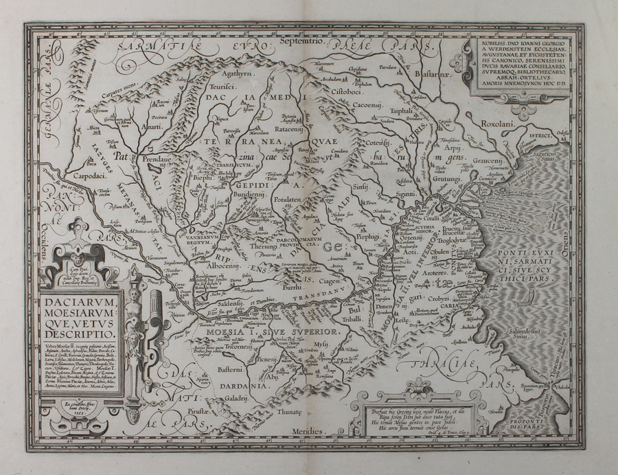
A map of ancient Dacia and Moesia, roughly corresponding to modern day Romania and Bulgaria, originally published for the 1595 Parergon (Supplement) of Ortelius' famous Theatrum Orbis Terrarum. This particular example is unusual in having no verso text. The map is likely either one of a number of Ortelius' ancient world maps sold to Petrus Bertius for inclusion in his Theatrum Geographiae Veteris, or similarly a single issue sold by Vrients for inclusion in an extra-illustrated book or composite atlas. The map depicts the extent of the ancient kingdoms and tribal lands of the Getic and Dacian people, to the north and south of the River Danube, as well as the adjoining parts of the Roman provinces and ancient regions of Sarmatia, Germania, Pannonia, Dalmatia, and Thracia, and the western reach of the Black Sea. The largest concentration of settlements appears on the southern bank of the Danube and the frontier of Roman Moesia. The Dacian capital of Sarmizegetusa, destroyed by Trajan during the Dacian Wars and refounded as the capital of the new Roman province of Dacia under the name Ulpia Traiana Sarmizegetusa, is the largest settlement depicted, at the foothills of the Carpathian Mountain range. Just north of the confluence of the Danube and Tissus (the modern Tisza) Rivers is the massive complex of Felix Romuliana, modern Gamzigrad, built by the early 4th century AD Roman Emperor Galerius. Galerius, whose mother was Dacian, constructed the site as a grand imperial palace, and cult sanctuary. As Ortelius notes on the map, Galerius was buried there, after succumbing to a horrific disease described in florid detail by the early Christian writers Eusebius and Lactantius. The map is further ornamented by three strap-work cartouches, enclosing the title and a list of place names of unknown location, a dedication to the Bavarian duke and renowned bibliophile Johann Georg of Werdenstein, and a four line passage from Ovid's Tristia ex Ponto about the Straits of the Bosphorus. The Parergon ('Supplement') was, as the title suggests, originally conceived of as a supplement to Ortelius' Theatrum. The work, a massive and intricately researched index of the classical world, was accompanied by a series of ancient world maps. Unlike the maps of the Theatrum, the majority of which were reductions of earlier maps, the maps of the Parergon were researched and drawn by Ortelius himself. The work was a huge commercial success, and the maps themselves set the standard for ancient world maps for the duration of the seventeenth century, being reproduced or reprinted by various publishers after Ortelius' final 1624 printing. His interest in the mapping of the ancient world is manifest. The maps of the Parergon are a veritable mine of textual commentary and classical philology, drawing upon Ptolemy, Strabo, Pliny, and many others. Interestingly, the project seems to have been a labour of love, rather than a mercantile venture. Ortelius himself was fascinated with the ancient world, and a formidable classical scholar in his own right. In addition to his work as a cartographer, he dealt in antiquities, visited and surveyed ancient sites across Europe, published a critical edition of Caesar's Gallic Wars in 1593, and assisted Welser in his studies of the famous Tabula Peutingeriana in 1598, producing an engraved copy of the map that can be found in later editions of the Parergon. Abraham Ortelius (1527 -1598) was a Flemish cartographer, cosmographer, geographer and publisher and a contemporary of Gerard Mercator, with whom he travelled through Italy and France. Although it is Mercator who first used the word "Atlas" as a name for a collection of maps, it is Ortelius who is remembered as the creator of the first modern atlas. Theatrum Orbis Terrarum was the first systematically collated set of maps by different map makers in a uniform format. Three Latin editions as well as a Dutch, French and German edition of Theatrum Orbis Terrarum were published by 1572 and a further 25 editions printed before Ortelius' death in 1598. Several more were subsequently printed until around 1612. Ortelius is said to have been the first person to pose the question of the continents once being a single land mass before separating into their current positions. Ex.Col.: László Gróf Condition: Clean, crisp impression with full margins. Central vertical fold. Minor time toning to fold. Blank on verso. |
| Framing | unmounted |
| Price | £600.00 |
| Stock ID | 51015 |