
| Method | Woodcut with hand colour |
| Artist | Münster, Sebastian |
| Published | [Basel, c.1550] |
| Dimensions | 265 x 165 mm |
| Notes |
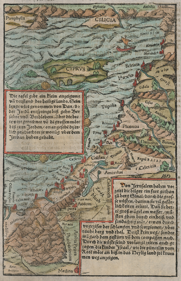
A characterful sixteenth century woodcut map of the Holy Land, from a German edition of Munster's celebrated Cosmographia. The map, the first of two Münster maps of the Holy Land, was issued in editions of the Cosmographia until it was replaced with a larger double-sheet map of Asia Minor and Mesopotamia in 1588. The current map, printed on a single sheet, stretches from the Nile Delta and the Sinai at south to Cilicia and Pamphylia on the Turkish coast in the north, encompassing the whole Levantine coast, as well as the island of Cyprus. Principal cities and towns are picked out in red, mountains, forests, and lakes are shown pictorially, and the region is divided into its biblical nations, including the territories of the Twelve Tribes of Israel. Two large boxed cartouches provide descriptions in German of the region. Sebastian Münster (20th January 1488 - 26th May 1552) was a German cartographer, cosmographer, and theologian. A gifted scholar of Hebraic, Münster originally joined the Franciscans, but left the order in favour of the Lutheran Church. He was appointed to the University of Basel in 1529, and published a number of works in Latin, Greek, and Hebrew. His most celebrated works are his Latin edition of Ptolemy's Geographia in 1540, and the Cosmographia in 1544. The Cosmographia was the earliest German description of the world, an ambitious work of 6 volumes published in numerous editions in German, Latin, French, Italian, and Czech. Henricus Petrus (1508-1579) was a German printer and published, whose print-works in Basel produced some of the most influential works of the German Renaissance, including Copernicus' De revolutionibus orbium coelestium and Munster's Cosmographia. Condition: Minor time toning to edges of sheet. German text above and on verso. |
| Framing | unmounted |
| Price | £300.00 |
| Stock ID | 52005 |