
| Method | Copper engraved |
| Artist | Ortelius, Abraham |
| Published | Cum Imp. et Regio privilegio decennali 1579 [Antwerp, 1598] |
| Dimensions | 358 x 496 mm |
| Notes |
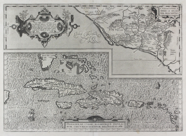
A pair of late sixteenth century maps of the Spanish Americas, from the 1598 French edition of Ortelius' famous Theatrum Orbis Terrarum. At top is a map of the territory of Culiacana, roughly equal with modern day Sinaloa State. The many pre-Columbian villages and settlements are plotted, along with the colonial towns of Culiacan and Villa San Michaelis (San Miguel de Culiacán), both shown as miniature towns, and with the cathedral of San Miguel marked with a crucifix. Rivers and mountain ranges are depicted, as is a large palm grove north of Culiacan. In the top right, a strapwork cartouche encloses the title, while a larger and more ornate example in the Gulf of California notes that the anonymous cartographer upon which the map is based used Toledo as his prime meridian, rather than the usual Fortunate Isles, by which Ortelius means the Azores. Historically, the map is an interesting one less for its cartography, than for its connection to the early history of European exploration of California and the West Coast of Mexico and the United States. Culiacan was the furthest point north on the Mexican mainland reached by Hernando Cortes in his search for the famous Seven Cities of Gold. Across the Gulf, in the southern part of Baja California, he described an ideal harbour, usually thought to be the harbour of La Paz. Stories of the Seven Cities of Gold circulated throughout the sixteenth century, encouraging a number of other explorers after Cortes. Francisco de Ulloa, privately funded by Cortes, set out in 1539 from Acapulco and circumnavigated the coasts of the Gulf of California, sailing north along the western coast of Baja as far as Isla Natividad. The following year, Francisco Vazquez de Coronado set out to find the cities by an overland route, following the coast of the Gulf of California as far as San Miguel before turning inland, eventually travelling as far north as Kansas, though finding nothing but adobe huts in place of the 'streets paved with gold' that the legends had promised. At the bottom of the plate is a beautiful and detailed map of the Caribbean, centred on the islands of Cuba and 'Aity, sive Spaniola' (Haiti, or Hispaniola). The various colonial settlements on the islands are marked with icons relative to their size and importance, while two ships sail the hatchured oceans. To the extreme left, the tip of the Yucatan peninsula and the island of Cozumel breaks the border, while the southernmost reaches of Florida and the Florida Keys can be seen at top. In the centre of the Bahamas islands, a treacherous stretch of water and reefs is labelled as 'Great Carybdis,' no doubt inspired by the infamous whirlpools of Greek mythology, while another patch of reef north of Hispaniola is represented as Charybdis' mythic partner, the monster Scylla. The rest of the Antilles are depicted in impressive detail, stretching from St Juan (Puerto Rico) to Baruados (Barbados), which, along with St Lucia, is squeezed into the border at bottom right. Ortelius' explanatory notes on the verso make it clear why Cuba was such an attractive prospect for the Spanish colonists, with the island's abundance of gold, precious stones, and exotic textile dyes matched by lush forests, sweet water, and even a natural supply of bitumen for tarring ships. Abraham Ortelius (1527 -1598) was a Flemish cartographer, cosmographer, geographer and publisher and a contemporary of Gerard Mercator, with whom he travelled through Italy and France. Although it is Mercator who first used the word "Atlas" as a name for a collection of maps, it is Ortelius who is remembered as the creator of the first modern atlas. Theatrum Orbis Terrarum was the first systematically collated set of maps by different map makers in a uniform format. Three Latin editions as well as a Dutch, French and German edition of Theatrum Orbis Terrarum were published by 1572 and a further 25 editions printed before Ortelius' death in 1598. Several more were subsequently printed until around 1612. Ortelius is said to have been the first person to pose the question of the continents once being a single land mass before separating into their current positions. Condition: Central vertical fold as issued. Tear repair to top of central fold, not affecting image or plate. Manuscript number '8' in top right corner. |
| Framing | unmounted |
| Price | £800.00 |
| Stock ID | 44649 |