
| Method | Steel engraved with original hand colour |
| Artist | Wyld, James |
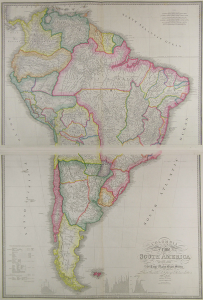
| Published | London. Published by Jas. Wyld, Geographer to Her Majesty. Charing Cross East. & Model of the Earth, Leicester Square. 1854. |
| Dimensions | 552 x 769 mm |
| Notes |
A finely detailed hand coloured map of South America printed over two sheets, from James Wyld's A New General Atlas of Modern Geography. Map based on the eight sheet map of South America (called Colombia Prima) by Delarochette, first published by William Faden in 1807, Wyld's predecessor as Royal Geographer in 1807. Wyld revised this map a number of times during the nineteenth century, publishing it both in its original size, and as this smaller two sheet version in his Atlas. Map includes numerous interesting details concerning the native inhabitants, and also gives topographical profiles of the Andes. Decorative calligraphic title. James Wyld (1812-1887) was a British publisher and cartographer. His greatest geographical achievement was Wyld's Great Globe, exhibited in Leicester Square between 1851 and 1862. The globe, sixty feet high and lighted with gas, was at that point the largest ever constructed. He was geographer to Queen Victoria and H.R.H. Prince Albert. Condition: Centre folds, as issued. |
| Framing | unmounted |
| Price | £375.00 |
| Stock ID | 41866 |