
| Method | Woodcut |
| Artist | Bordone, Benedetto |
| Published | [Venice, 1528] |
| Dimensions | 82 x 142 mm |
| Notes |
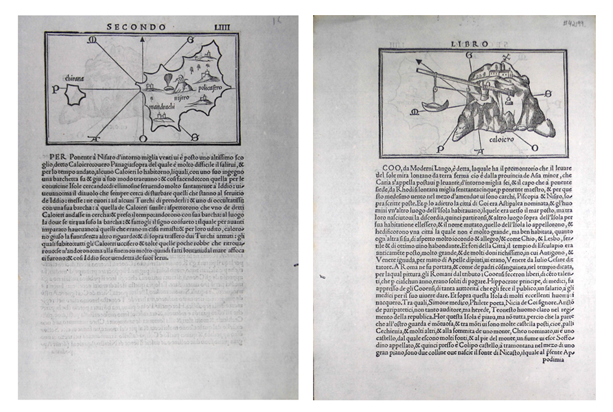
A double sided sheet from Bordone's famous Isolario ('Book of Islands'), featuring a pair of simple woodcut maps of Aegean islands. The recto depicts the islands of Nisyros (Nisaro) and Giali (Chirana), superimposed over an eight-pointed line compass. The towns of Mandraki and Polikastro are clearly marked, and a further three unmarked settlements are plotted with simple illustrations of towns. The centre of the island appears to feature a large volcano, near some form of geyser or hot spring. On the verso, the small rocky island of Caloiero is shown, again superimposed over an eight-pointed line compass. The island's only features are a small church, probably representing a monastery, and a crane with weight and pulley designed to lift boats and their cargo up the steep rocky slopes of the island's coastline. The island's identity is unknown, though the most likely candidates are the similarly named Kalogeroi, an uninhabited rocky island in the straights between Andros and Tinos, and Kandelioussa, off the coast of Nisyros. Of the two, the latter is the most likely to be the island here represented, as a number of other cartographers make reference to a sea-crane in use on the island until its destruction by earthquake or volcanic activity at some point in the early 18th century. Both maps are described below by explanatory text in Italian. Benedetto Bordone (1460-1531) was an Italian cartographer, author, and miniaturist. Born in the university town of Padua, and active as a publisher in Venice, Bordone is chiefly remembered for his Isolario of 1528, a work detailing the history, geography, mythology, climate, and position of the islands of the world. The book, featuring woodcut illustrations of most of the islands mentioned in the text, was intended as a guide for sailors, and was one of the first works to provide widely accessible details of the lands of the New World. Among the most important of Bordone's contributions to cartography are his pre-Columbian plan of the Aztec Capital Tenochtitlan, the first western printed map of Japan as an island, and the use of an oval-from world map. Condition: Excellent clear impressions on clean sheet. Small insect hole to margin, not affecting maps or text. |
| Framing | unmounted |
| Price | £150.00 |
| Stock ID | 42199 |