
| Method | Copper engraved with hand colour |
| Artist | Ortelius, Abraham |
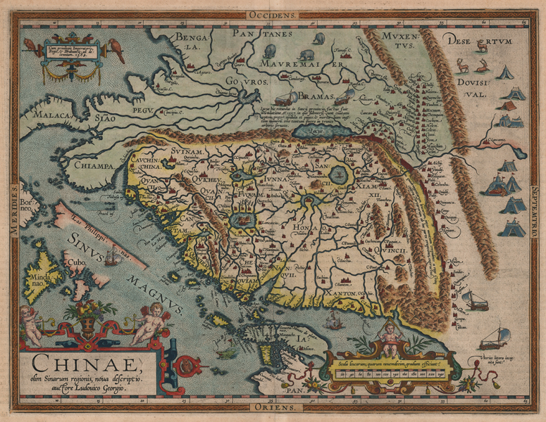
| Published | auctore Ludovico Georgio. Cum privilegio Imperatoris, Regis, & Brabantie, ad decennium 1584. [1601] |
| Dimensions | 365 x 470 mm |
| Notes |
A 1601 printing of the first map of China to appear in an atlas, from a Latin edition of Ortelius' famous Theatrum Orbis Terrarum. The map is oriented with west to top, and encompasses China, the southeast Asian peninsula, parts of India, Mongolia, Russia, Japan, the Philippines, and Borneo. Ornamented in beautiful full hand colour and with principal cities picked out in red, the map also features illustrations of elephants in India, deer and a series of colourful tents in Tartary, ships, sea monsters, and most interestingly, four sail-powered wind-ships. The Great Wall is shown pictorially, though the descriptive text, while correctly describing its defensive purpose against the Tartars and Mongols, grossly underestimates its true length. Likewise Japan is shown on a strange curved orientation, and even China itself seems dramatically foreshortened in this projection. A note on the mountainous borders between China and India describes the creation of a large lake in a recent flood, of which the only survivor was a small boy who sheltered in a tree trunk. Another note in the bottom right corner of the plate describes the extent of the northeast coastline of the continent as unknown. The map is further ornamented by a trio of elaborate strapwork cartouches, containing the privilege, the title, and a scale. Ortelius attributes the map's geography to Ludovico Georgio, usually identified as the Portuguese cartographer Luiz Jorge de Barbuda. Abraham Ortelius (1527 -1598) was a Flemish cartographer, cosmographer, geographer and publisher and a contemporary of Gerard Mercator, with whom he travelled through Italy and France. Although it is Mercator who first used the word "Atlas" as a name for a collection of maps, it is Ortelius who is remembered as the creator of the first modern atlas. Theatrum Orbis Terrarum was the first systematically collated set of maps by different map makers in a uniform format. Three Latin editions as well as a Dutch, French and German edition of Theatrum Orbis Terrarum were published by 1572 and a further 25 editions printed before Ortelius' death in 1598. Several more were subsequently printed until around 1612. Ortelius is said to have been the first person to pose the question of the continents once being a single land mass before separating into their current positions. Condition: Central vertical fold as issued, strengthened at base on verso. Minor time-toning to margins. Some show-through from verso text. Latin text on verso. |
| Framing | mounted |
| Price | £4,750.00 |
| Stock ID | 52046 |