
| Method | Copper engraved |
| Artist | Blaeu, Willem Janszoon |
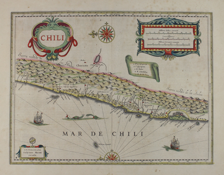
| Published | Amstelodami Guiljelmus Blaeuw excudit. [c.1640] |
| Dimensions | 352 x 475 mm |
| Notes |
Willem Blaeu's map of Chile, from a Latin edition of the Atlas Novus, and, alongside that of his chief rivals the Hondius family, the earliest separate map of Chile to appear in an atlas. The map is oriented with East to top, and outlined in beautiful hand colour with principal towns and settlements picked out in red. The map stretches from Isla Grande de Chiloe at right to Puerto Viejo at left, bordered all the way along by the Andes, shown pictorially. The only settlements beyond the 'Sierra Nevado de los Andes' are the Argentinian towns of Mendoza and San Juan. The blank spaces of the map are largely filled with decorative flourishes, including a large scale in Gallic, Spanish, and German miles, a numbered key in a ribbon, a baroque title cartouche, a pair of compass roses, a pair each of sailing ships and sea monsters, and the Blaeu's imprimatur topped by an armillary sphere. The Blaeu family were one of the most famous publishers of maps, globes and atlases during the seventeenth-century. Cartographers, globe makers and booksellers, the Blaeu business flourished in Amsterdam for over 40 years, until a fire destroyed their premises in 1672. They lost all of their plates, prints and stock, which effectively ruined the firm. Willem Janzoon Blaeu (1571-1638) founded the family business in 1596. It initially functioned as a globe and instrument makers, but soon expanded into maps, topography and sea charts. The acquisition of thirty-eight copper plates from the estate of Jodocus Hondius in 162 together with twenty-two of his own maps enabled Blaeu to produce his first atlas, the 'Atlas Appendix' in 1630. The Atlas Novus was Willems great work; a major work which intended to include the most up-to-date maps of the entire world. He issued the first two volumes in 1635, but died in 1638 before the atlas was completed. The running of the business was passed on to his sons Johannes (c.1596-1673) and Cornelius, in addition to the role of the official cartographer of the East India Company. After the death of Cornelius in 1644, Johannes continued the business alone and established his own reputation as a great mapmaker. Johannes completed his father's grand project, culminating in 1658 in the production of the famous 'Atlas Major', regarded as one of the greatest achievements in the history of cartography. The county maps of England and Wales formed volume four of Blaeu's great atlas, this volume being first published in 1645 and re-issued without any alterations in 1662 as the fifth volume instead of the fourth. Condition: Central vertical fold, as issued. Minor time toning and foxing to sheet. Edges of sheet gilded. Latin text on verso. Old adhesive stains to verso. |
| Framing | unmounted |
| Price | £400.00 |
| Stock ID | 48360 |