
| Method | Copper engraved with hand colour |
| Artist | Mortier, Pierre |
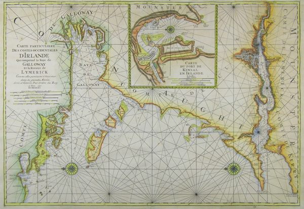
| Published | Levée et Gravée Pare Ordre, A. Paris, 1693. |
| Dimensions | 595 x 855 mm |
| Notes |
A first edition of this impressive sea chart of the Limerick River and Galway Bay with an inset plan of the port of Kinsale from Le neptune François. Moriter's plates were later acquired by the French Depot De La Marine and republished. This is an early state of this map still retaining the Ordre du Roy and Paris 1693 publication line. Pieter Mortier (1661–1711) was an 18th-century mapmaker and engraver from the Northern Netherlands. Mortier was born in Leiden. According to Houbraken, David van der Plas worked with him on etchings for Bybelsche Tafereelen (Bible stories), published in Amsterdam in 1700. He was the father of Cornelis Mortier (1699-1783), who in partnership with Johannes Covens I (1697-1774) began the map publishing company Covens & Mortier (1721-1866). He travelled to Paris in 1681-1685 and won the privilege in 1690 of publishing maps and atlases by French publishers in Amsterdam. He used this privilege to win a similar set of privileges for printing an "illustrated print bible" in 1700. He died in Amsterdam. Condition: On two joined sheets as issued. Time toning to verso. Some strengthening to upper left corner on verso. |
| Framing | unmounted |
| Price | £850.00 |
| Stock ID | 39208 |