
| Method | Copper engraved with original hand colour |
| Artist | Brué, Adrien-Hubert |
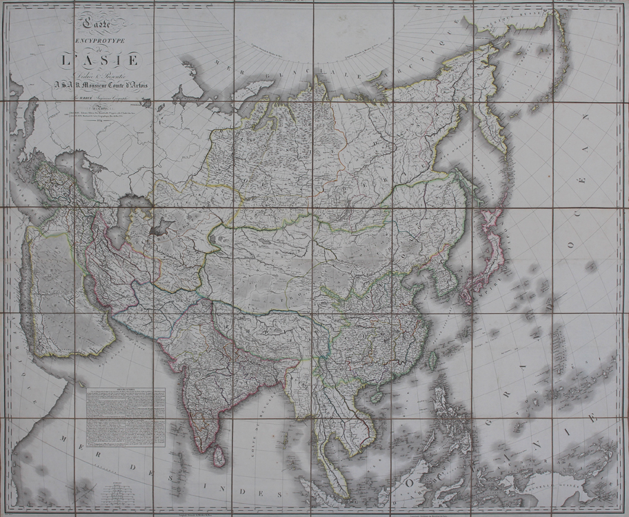
| Published | Par H. Brué Ingenieur Geographe. a Paris. Chez Desray, Libraire-Editeur Rue Hautefeuille No. 4 pres celle St. Andre des Arcs, J. Goujon, Marchand de Cartes Geographiques, Rue du Bac, No. 6. 1814 |
| Dimensions | 1115 x 1320 mm |
| Notes |
A very large early nineteenth century folding chart of the continent of Asia, engraved by Brué as part of a series of large scale charts he produced for the Parisian publishing houses of Desray and Goujon. Later editions were also published in book form, in Brué's rare Atlas Universel. Brué described the series as 'Encyprotypes,' a term he coined to emphasise the obvious pride he took in having engraved the map directly onto the copper printing plate himself, rather than having had a separate engraver carry out the engraving from a hand drawn draught, as was the more usual practice amongst his peers. The current example is a first printing, ornamented in beautiful original outline colour, and sectioned into 40 panels laid to linen as issued. The map stretches from the Bosphorus and the Red Sea in the West to Japan, Kamchatka, and the Bering Strait in the East. The westernmost reaches of Alaska are also shown at the extreme top right of the map, marked here as Amerique Russe. National and regional borders are marked in hand coloured outline, and adjoining parts of Africa, Europe, and the unmapped parts of the Arctic Circle are left uncoloured. Although the map encompasses much of South Asia, including the Indian Subcontinent, Sri Lanka, and mainland south east Asia, modern day Indonesia and New Guinea are only partially shown. French convention at the time the map was issued considered most of the southern islands of the Asian continent to be part of Oceania, and as such they are left uncoloured here. A large boxed text in the Indian Ocean provides two columns of Observations. In the large title in the top left corner, the map is 'Dediee & Presentee a S.A.R. Monsieur Comte d'Artois,' the future Charles X, King of France. The map was issued in 1814, the same year that the Sixth Coalition successfully overthrew Napoleon and re-established the monarchy under Louis XVIII, Charles' older brother, so it is likely that Brué's dedication may have been a timely and tactful attempt at gaining Royal patronage. Adrien-Hubert Brué (1786-1832) was a French cartographer and publisher. Having served as a cabin-boy in the Baudin expedition, gaining personal experience of Australia and the South Seas, he returned to Paris in adulthood and became a cartographer and geographical author, best known for his Atlas Universel. Charles Picquet (1771-1827) was a French cartographer and engraver, who served as geographer to Napoleon, and then under the Restoration to Louis XVIII and Charles X. His maps appeared largely in the Atlas universel de géographie physique, politique, ancienne et moderne of Adrien-Hubert Brué, though a number were separately issued, particularly as folding maps.45 Condition: Excellent clean example with vibrant original hand colour. Dissected and laid to linen, as issued. Minor creasing and time toning to edges of sheets. Pastedown label for 'Ch. Picquet, Geographe ordinaire du Roi' to verso. |
| Framing | unmounted |
| Price | £1,750.00 |
| Stock ID | 52032 |