
| Method | Copper engraved with original hand colour |
| Artist | Brué, Adrien-Hubert |
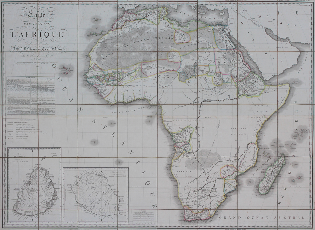
| Published | Par H. Brué Ingenieur Geographe. a Paris. Chez Desray, Libraire-Editeur Rue Hautefeuille No. 4 pres celle St. Andre des Arcs, J. Goujon, Marchand de Cartes Geographiques, Rue du Bac, No. 6. 1814 |
| Dimensions | 990 x 1320 mm |
| Notes |
A very large early nineteenth century folding chart of the continent of Africa, engraved by Brué as part of a series of large scale charts he produced for the Parisian publishing houses of Desray and Goujon. Later editions were also published in book form, in Brué's rare Atlas Universel. Brué described the series as 'Encyprotypes,' a term he coined to emphasise the obvious pride he took in having engraved the map directly onto the copper printing plate himself, rather than having had a separate engraver carry out the engraving from a hand drawn draught, as was the more usual practice amongst his peers. The current example is a first printing, ornamented in beautiful original outline colour, and sectioned into 40 panels laid to linen as issued. The map shows the entire continent, as well as the various islands of the Indian and Atlantic oceans. National and regional borders are marked in hand coloured outline, and adjoining parts of southern Europe, Asia, and the Arabian peninsula are left uncoloured. The majority of the southern half of the continent, with the exception of Angola and parts of Congo, as well as the coasts from Mozambique to the Cape of Good Hope, is left unmapped, with an inscription labelling the region as 'Partie entierement inconnue aux Europeen' - The part entirely unknown to Europeans. Mountain ranges in this region are shown, though listed as 'Supposee.' The islands of the Indian Ocean, the majority of which were under French control at the time the map was issued, are shown in detail, with two large inset maps in the bottom left corner showing Ile de France and Ile Bourbon, present day Mauritius and Réunion. A large boxed text featuring two columns of Observations and a key to the map are included above the insets, to the southwest of the Cabo Verde Islands. In the large title in the top left corner, the map is 'Dediee & Presentee a S.A.R. Monsieur Comte d'Artois,' the future Charles X, King of France. The map was issued in 1814, the same year that the Sixth Coalition successfully overthrew Napoleon and re-established the monarchy under Louis XVIII, Charles' older brother, so it is likely that Brué's dedication may have been a timely and tactful attempt at gaining Royal patronage. Adrien-Hubert Brué (1786-1832) was a French cartographer and publisher. Having served as a cabin-boy in the Baudin expedition, gaining personal experience of Australia and the South Seas, he returned to Paris in adulthood and became a cartographer and geographical author, best known for his Atlas Universel. Charles Picquet (1771-1827) was a French cartographer and engraver, who served as geographer to Napoleon, and then under the Restoration to Louis XVIII and Charles X. His maps appeared largely in the Atlas universel de géographie physique, politique, ancienne et moderne of Adrien-Hubert Brué, though a number were separately issued, particularly as folding maps. Condition: Excellent clean example with vibrant original hand colour. Sectioned and laid to linen, as issued. Minor creasing and time toning to edges of sheets. Pastedown label for 'Ch. Picquet, Geographe ordinaire du Roi' to verso. |
| Framing | unmounted |
| Price | £1,000.00 |
| Stock ID | 52033 |