
| Method | Copper engraved |
| Artist | Bellin, Jacques Nicolas |
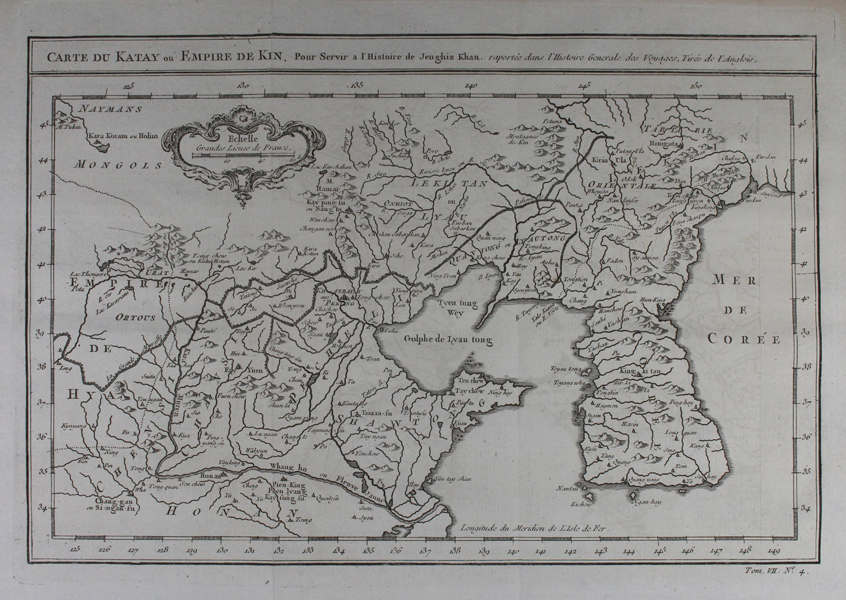
| Published | raportee dans l'Histoire Generale des Voyages, Tiree de l'Anglois. [Paris, c.1765] |
| Dimensions | 205 x 310 mm |
| Notes |
A map of the historic region of Cathay, roughly equating modern day northern China and southern Mongolia, engraved by Bellin for the monumental travel narrative, l'Histoire Generale des Voyages. The map is intended to illustrate the Mongol empire of Genghis Khan. The various parts of the Great Wall of China are shown as crenellated lines, and the Korean peninsula is also shown. In the top left, next to the old Mongol capital of Karakorum, the scale is enclosed by a scalloped baroque cartouche. The Histoire Géneral des Voyages was a monumental eighteenth century general history divided according to geographic region. The original volumes were written by Antoine François Prévost d'Exiles, a French author, novelist, theologian, natural historian, and a priest of the Jesuit and Benedictine orders, but continued by numerous other authors after Prévost's death. The earliest books mostly deal with the Far East and South-East Asia, providing a general history of their regions, kingdoms, customs, culture, costumes, natural phenomena and religious beliefs. Much of Prévost's information is derived from the reports of Jesuit missionaries, Portuguese merchants, and famous explorers, from Marco Polo to Sir Francis Drake. Although written in French, the popularity of the Histoire among Dutch audiences meant that many of the illustrative plates and maps published to accompany the work were either re-engraved or subtitled in Dutch by the engraver Jakob van der Schley. Prévost himself had travelled widely throughout the Netherlands, launching his literary career in Amsterdam and the Hague after fleeing the Benedictines in France. Prevost's work on China, and indeed many of van der Schley's plates, owe a great debt to Johan Nieuhoff (1618-1672) , a Dutch traveller who explored much of China, India, and Brazil while in the employ of the Dutch East India Company. Nieuhoff wrote extensively, with a particular focus on China, for his memoirs, and his numerous drawings of Chinese places and people were much copied by later engravers for numerous works of Chinese interest. Nieuhoff's own book became a major source of inspiration for eighteenth century chinoiserie, and are amongst the first western illustrations to depict the Chinese people in a manner which was based upon personal observation rather than the tradition of oriental fantasy. Jacques Nicolas Bellin (1703-1772) was a French hydrographer, geographer, and member of the French intellectual group the Philosophes. Bellin was born in Paris. He was hydrographer of France's hydrographic office, member of the Académie de Marine and of the Royal Society of London. Over a 50 year career, he produced a large number of maps of particular interest to the Ministère de la Marine. His maps of Canada and of French territories in North America (New France, Acadia, Louisiana) are particularly valuable. He died at Versailles. Condition: Vertical folds, as issued. Minor time toning to edges of sheet. |
| Framing | unmounted |
| Price | £300.00 |
| Stock ID | 47366 |