| Method | Copper engraved with early hand colour |
| Artist | de l'Isle, Guillaume |
| Published | Par G. de L'Isle Geographe de l'Academie Royale des Sciences. A Amsterdam Chez Jean Covens et Corneille Mortier Avec Privilege [Amsterdam, c.1740] |
| Dimensions | 485 x 615 mm |
| Notes |
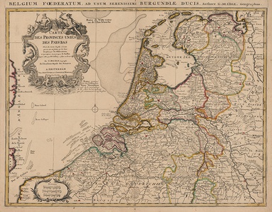
De l'Isle's large scale map of Belgium and the Netherlands, encompassing in addition parts of Germany, France, and the easternmost coasts of England. Regional and national borders are outlined in hand colour, principal cities are picked out in red, and mountains, rivers, and marshes and fenland are shown pictorially. In the top left corner, a baroque title cartouche is flanked by allegorical emblems representing the importance of the Dutch Republics as centres of maritime trade. Cherubs string a net from the bottom of the cartouche above a stylized dolphin, fish-tailed figures hold garlands of sea-weed, and Neptune and Mercury sit above. Another decorative cartouche in the bottom left encloses a scale in Dutch, German, and French miles. A superscript title in latin reads: 'Belgium Foederatum, ad Usum Serenissimi Burgundiae Ducis. Authore G. De l'Isle, Geographus.' This particular example is a Covens and Mortier reissue of de l'Isle's map, printed in Amsterdam and most likely from one of the company's many composite atlases. De l'Isle's originally plate has been slightly reworked to correct the mapping of Belgium. The original plate, from 1702, labels much of Belgium as 'Pays Bas Espagnols.' After the Treaty of Rastatt in 1714, the map was updated, as here, to 'Pays Bas d'Autrichien' to represent the acquisition of the Spanish Netherlands by the Austrian Habsburgs. Guillaume de l'Isle (1625 - 1726) was one of the finest cartographers of the eighteenth-century. He is widely regarded as the father of scientific mapmaking, and was the first to utilise the practices of triangulation and mensuration in the production of his works. He believed strongly in the importance of map accuracy. During his lifetime his one hundred or more maps were continuously updated to reflect widening knowledge of the World. Cornelis Mortier (1699-1783) in partnership with Johannes Covens I (1697-1774) began the map publishing company Covens & Mortier (1721-1866). He travelled to Paris in 1681-1685 and won the privilege in 1690 of publishing maps and atlases by French publishers in Amsterdam. He used this privilege to win a similar set of privileges for printing an 'illustrated print bible' in 1700. He died in Amsterdam. Son of Pieter Mortier (1661–1711) an 18th-century mapmaker and engraver from the Northern Netherlands. Mortier was born in Leiden. According to Houbraken, David van der Plas worked with him on etchings for 'Bybelsche Tafereelen' (Bible stories), published in Amsterdam in 1700. Condition: Central vertical fold, as issued. Central horizontal creases. Some splitting to top and bottom of central fold, not affecting map. Foxing and minor time toning to margins. Verdigris from old colour on verso, otherwise blank. |
| Framing | unmounted |
| Price | £375.00 |
| Stock ID | 53445 |

