
| Method | Copper engraved with hand colour |
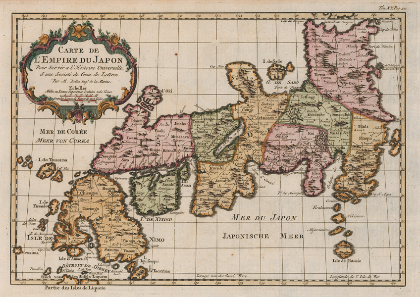
| Artist | Bellin, Jacques Nicolas |
| Published | Par M.Bellin Ingr. de la Marine [Paris, c.1750] |
| Dimensions | 203 x 302 mm |
| Notes |
An attractive map of Japan, presented in full wash colour, published in the Abbe Prevost's monumental 'l'Histoire Géneral des Voyages. The map charts the coast line of Japan, and the islands are divided into provinces, with each region further divided into the territories of the daimyo. The title is enclosed in a baroque decorative cartouche to the top left. The Histoire Géneral des Voyages was a monumental eighteenth century general history divided according to geographic region. The original volumes were written by Antoine François Prévost d'Exiles, a French author, novelist, theologian, natural historian, and a priest of the Jesuit and Benedictine orders, but continued by numerous other authors after Prévost's death. The earliest books mostly deal with the Far East and South-East Asia, providing a general history of their regions, kingdoms, customs, culture, costumes, natural phenomena and religious beliefs. Much of Prévost's information is derived from the reports of Jesuit missionaries, Portuguese merchants, and famous explorers, from Marco Polo to Sir Francis Drake. Although written in French, the popularity of the Histoire among Dutch audiences meant that many of the illustrative plates and maps published to accompany the work were either re-engraved or subtitled in Dutch by the engraver Jakob van der Schley. Prévost himself had travelled widely throughout the Netherlands, launching his literary career in Amsterdam and the Hague after fleeing the Benedictines in France. Jacques Nicolas Bellin (1703-1772) was a French hydrographer, geographer, and member of the French intellectual group the Philosophes. Bellin was born in Paris. He was hydrographer of France's hydrographic office, member of the Académie de Marine and of the Royal Society of London. Over a 50 year career, he produced a large number of maps of particular interest to the Ministère de la Marine. His maps of Canada and of French territories in North America (New France, Acadia, Louisiana) are particularly valuable. He died at Versailles. Condition: Vertical folds, as issued. Minor time toning to edges of sheet. Blank on verso. |
| Framing | unmounted |
| Price | £375.00 |
| Stock ID | 51994 |