
| Method | Copper engraved with early hand colour |
| Artist | de l'Isle, Guillaume |
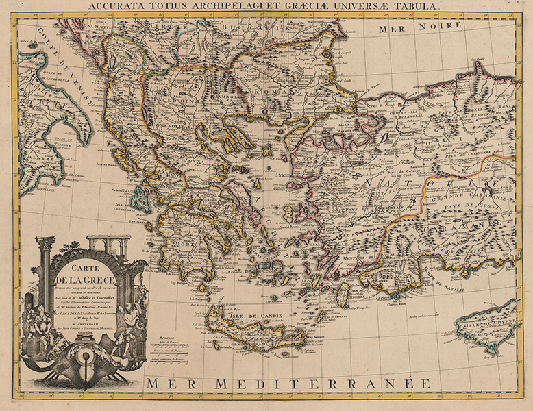
| Published | Par G. de L'Isle de l'Academie Rle. des Sciences et Ier. Geog. du Roy. a Amsterdam Chez Jean Covens et Corneille Mortier Geographes [Amsterdam, c.1740] |
| Dimensions | 455 x 590 mm |
| Notes |
De l'Isle's large scale map of Greece, encompassing in addition to the Greek mainland and islands, parts of Macedonia, Albania, Croatia, Serbia, Bulgaria, Romania, Turkey, Cyprus, and southern Italy. Regional and national borders are outlined in hand colour, principal cities are picked out in red, and mountains and rivers are shown pictorially. In the bottom left corner, a very large title cartouche takes the form of a large ships keel, a nod to the triremes that made the ancient Greeks such a famous maritime people. Above the keel, two allegorical figures sit in an Arcadian ruin of arches and Corinthian columns. On the right, a winged figure holds a large but broken urn, most likely a representation of the wealth of Greece, now eroded by Time. On the left, a female figure, likely Hellas herself, is yoked by a Turk, who stands behind. A superscript title in latin reads: 'Accurata Totius Archipelagi et Graeciae Universae Tabula.' This particular example is a Covens and Mortier reissue of de l'Isle's map, printed in Amsterdam and most likely from one of the company's many composite atlases. Guillaume de l'Isle (1625 - 1726) was one of the finest cartographers of the eighteenth-century. He is widely regarded as the father of scientific mapmaking, and was the first to utilise the practices of triangulation and mensuration in the production of his works. He believed strongly in the importance of map accuracy. During his lifetime his one hundred or more maps were continuously updated to reflect widening knowledge of the World. Cornelis Mortier (1699-1783) in partnership with Johannes Covens I (1697-1774) began the map publishing company Covens & Mortier (1721-1866). He travelled to Paris in 1681-1685 and won the privilege in 1690 of publishing maps and atlases by French publishers in Amsterdam. He used this privilege to win a similar set of privileges for printing an 'illustrated print bible' in 1700. He died in Amsterdam. Son of Pieter Mortier (1661–1711) an 18th-century mapmaker and engraver from the Northern Netherlands. Mortier was born in Leiden. According to Houbraken, David van der Plas worked with him on etchings for 'Bybelsche Tafereelen' (Bible stories), published in Amsterdam in 1700. Condition: Central vertical fold, as issued. Central horizontal creases. Some splitting to top and bottom of central fold, not affecting map. Foxing and minor time toning to margins. Verdigris from old colour on verso, otherwise blank.c |
| Framing | unmounted |
| Price | £500.00 |
| Stock ID | 53443 |