
| Method | Copper engraved with hand colour |
| Artist | Dezauche, Jean-Claude after De l'Isle, Guillaume and Buache, Philippe |
| Published | Revu et corrige en 1779. A Paris Rue des Noyers. Avec Priv.ge [c.1785] |
| Dimensions | 495 x 630 mm |
| Notes |
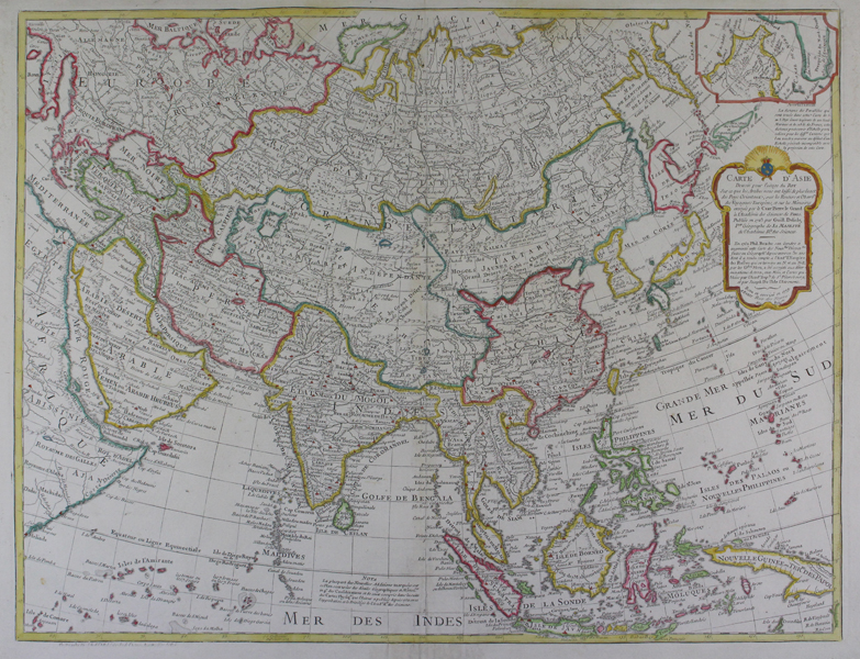
A large, impressive, and detailed map of the continent of Asia, originally mapped by De l'Isle and reviewed by Buache in 1779. Considering Dezauche only acquired Buache and De l'Isle's stock in 1780, the fact that this plate carries his imprimatur suggests a probably publication date of 1785. The map attempts to retain some sense of the curvature of the earth, a difficult task for a continent as wide as Asia. Stretching from the Mediterranean in the top left to the Kamchatka peninsula in top right, and from the Horn of Africa in bottom left to Papua New Guinea in bottom right, the map centres on the Indian subcontinent, here labelled as the 'Mogul' empire. China is relatively diminutive when compared to the territories of Tartaria and Russia. Korea is shown correctly as a peninsula, though Hokkaido, marked here as 'Ieso' is much larger than the rest of Japan. In the Indian Ocean, the Maldives, Comorros, and Andamans are mapped, as are the many islands of Indonesia and south east Asia. New Guinea is elongated, though almost all of its coastline is shown. In the top right corner, a boxed inset shows the Bering Strait, above a lengthy title cartouche. Jean-Claude Dezauche (c.1745-1824) was a French cartographer, engraver, and publisher. A continuator of Buache, and thus de l'Isle, Dezauche's work is often overlooked or misattributed. Dezauche acquired most of de l'Isle and Buache's stock in 1780, from Buache's nephew Jean-Nicolas, himself also an engraver and map-maker. Guillaume de l'Isle (1625 - 1726) was one of the finest cartographers of the eighteenth-century. He is widely regarded as the father of scientific mapmaking, and was the first to utilise the practices of triangulation and mensuration in the production of his works. He believed strongly in the importance of map accuracy. During his lifetime his one hundred or more maps were continuously updated to reflect widening knowledge of the World. Philippe Buache (1700-1773) was a French cartographer and geographer, and the pupil of Guillaume de l'Isle. He is best known for his Atlas physique of 1754. He hypothesised correctly about the existence of a southern continent, and contributed to geographical enquiry by devising the system of dividing the world according to seas and rivers. Condition: Central vertical fold, as issued. Blank on verso. |
| Framing | unmounted |
| Price | £500.00 |
| Stock ID | 46816 |