
| Method | Copper engraved with hand colour |
| Artist | Jan Jansson after Georg Braun and Frans Hogenberg |
| Published | [Amsterdam, c.1657] |
| Dimensions | 330 x 445 mm |
| Notes |
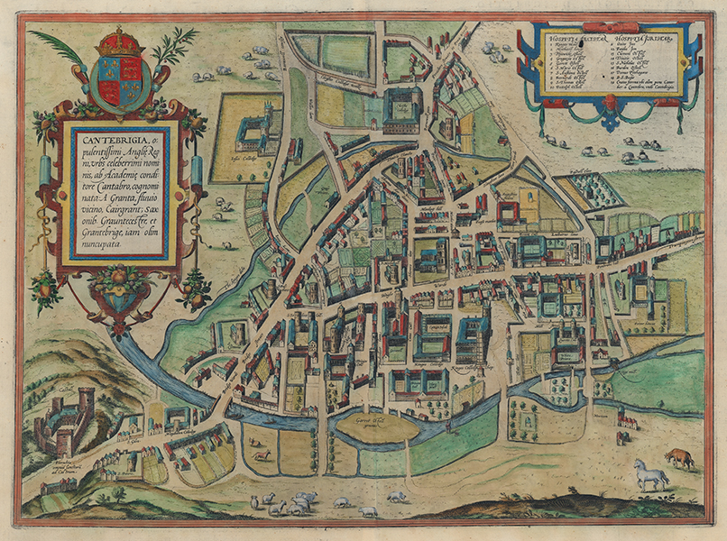
An aerial view of the city of Cambridge, from Jan Jansson's rare Theatrum Urbium. The current example is a slightly reworked reissue of the late sixteenth century view of the city from Georg Braun and Frans Hogenberg's Civitates Orbis Terrarum. The most notable change is the removal of the trio of large figures that originally stood in the bottom right corner of the map. The original Braun and Hogenberg plate, first issued in 1575, is almost certainly based upon the map by Richard Lyne engraved for John Caius' history of Cambridge published a year earlier. Indeed Lyne's patron, Archbishop of Canterbury Matthew Parker, also had in his employ Frans Hogenberg's brother Remigius. The city is shown from the west, looking across The Backs with the Granta (Cam) River in the foreground. Many of the colleges, churches, and public buildings are clearly identifiable, and the fields surrounding the city are busy with sheep. In the top right, a strapwork cartouche contains a numerical key of Cambridge's inns. The title is enclosed by another strapwork cartouche festooned with flora and fruit, and the Royal Arms. The full title reads: 'Cantebrigia, opulentissimi Angliae Regni, urbs celeberrimi nominis, ab Academiae conditore Cantabro, cognominata: A Granta, fluvio vicino, Cairgrant; Saxonib. Grauntecestre, et Grantabrige, iam olim nuncupata.' Johannes Janssonius (1588-1664) was a famed cartographer and print publisher. More commonly known as Jan Jansson, he was born in Arnhem where his father, Jan Janszoon the Elder, was a bookseller and publisher. In 1612 he married the daughter of the cartographer and publisher Jodocus Hondius, and then set up in business in Amsterdam as a book publisher. In 1616 he published his first maps of France and Italy and from then onwards, produced a very large number of maps which went some way to rival those of the Blaeu family, who held a virtual monopoly over the industry. From about 1630 to 1638 he was in partnership with his brother-in-law, Henricus Hondius, issuing further editions of the Mercator/Hondius atlases to which his name was added. On the death of Hondius he took over the business, expanding the atlas still further, until eventually he published an eleven volume Atlas Major on a scale similar to Johannes Blaeu's magnum opus. After Jansson's death, his heirs published a number of maps in the Atlas Contractus of 1666, and, later still, many of the plates of his British maps were acquired by Pieter Schenk and Gerard Valck, who published them again in 1694 as separate maps. Between 1572 and 1617 Georg Braun (1541-1622) and Frans Hogenberg (1535-1590) published six volumes of their Civitates Orbis Terrarum, containing over 500 prospects, views, and maps of mostly European cities, envisioned as a companion to Ortelius' atlas Theatrum Orbis Terrarum. Braun was the editor of the series, with Hogenberg as principle engraver. They relied mainly on existing cartography, but also on drawings made by the Antwerp artist Joris Hoefnagel (1542-1600), who had travelled through most of Western Europe. After Joris Hoefnagel's death his son Jakob continued the work for the Civitates. Condition: Central vertical fold, as issued. Repaired tears to top and bottom of central fold. Wormhole to bottom left margin, not affecting plate. Minor time toning to edges of sheet. Latin letterpress text on verso. |
| Framing | unmounted |
| Price | £1,750.00 |
| Stock ID | 53440 |