
| Method | Copper engraved with hand colour |
| Artist | Mercator, Gerard and Hondius, Jodocus |
| Published | [Amsterdam, c.1640] |
| Dimensions | 140 x 182 mm |
| Notes |
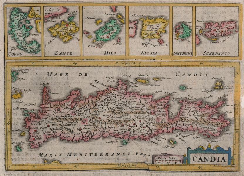
A decorative miniature map of Crete, with boxed maps of six Greek islands above, from a German edition of the Mercator-Hondius Atlas Minor. The current example was likely engraved by Keere for Jan Jansson's later editions of the Atlas Minor to replace an earlier Hondius plate of the same name and design that featured a slightly different title cartouche and only five rather than six inset maps above the main map of Crete. Crete, at the time this map was made, was under the control of the Venetian republic, and named Candia, after its principal city, modern day Heraklion. Unusually, in this example the city of Candia is uncoloured, where a number of other important cities and towns are picked out in red. A strapwork cartouche in the bottom right corner of the map encloses the title, and a scale in Italic miles. Above, six boxed maps depict various islands of the Greek archipelago with their Italian titles: Corfu, Zante (Zakynthos), Milo (Milos), Nicsia (Naxos), Santorini, and Scarpanto (Karpathos). Gerard Mercator (1512 - 1594) originally a student of philosophy was one of the most renowned cosmographers and geographers of the 16th century, as well as an accomplished scientific instrument maker. He is most famous for introducing Mercators Projection, a system which allowed navigators to plot the same constant compass bearing on a flat map. His first maps were published in 1537 (Palestine), and 1538 (a map of the world), although his main occupation at this time was globe-making. He later moved to Duisburg, in Germany, where he produced his outstanding wall maps of Europe and of Britain. In 1569 he published his masterpiece, the twenty-one-sheet map of the world, constructed on Mercator's projection. His Atlas, sive Cosmographicae Meditationes de Fabrica Mundi, was completed by his son Rumold and published in 1595. After Rumold's death in 1599, the plates for the atlas were published by Gerard Jr. Following his death in 1604, the printing stock was bought at auction by Jodocus Hondius, and re-issued well into the seventeenth century. Jodocus Hondius (14th October 1563 - 12th February 1612) was a Dutch Flemish cartographer, engraver, and publisher. Hondius is most famous for reviving the primacy of the work of Gerard Mercator, through the publication of his Atlas, and the smaller Atlas Minor, in the early seventeenth century, at a time when cartography was largely dominated by Ortelius' Theatrum Orbis Terrarum. The Mercator-Hondius Atlas was composed of maps pulled from plates Hondius had purchased from Mercator's grandson, as well as thirty-six new plates Hondius commissioned, and in many cases engraved, himself. He is also believed to have been the chief engraver of the plates for John Speed's Theatre of the Empire of Great Britaine. Following his death, he was succeeded by his sons, Jodocus the Younger and Henricus, as well as his son in law Jan Jansson. Condition: Minor time toning to edges of sheet. Large vertical printers crease to bottom half of map. Old repaired chip to right margin, not affecting map. German text above and on verso. |
| Framing | mounted |
| Price | £250.00 |
| Stock ID | 52439 |