
| Method | Copper engraved |
| Artist | Hermannides, Rutger |
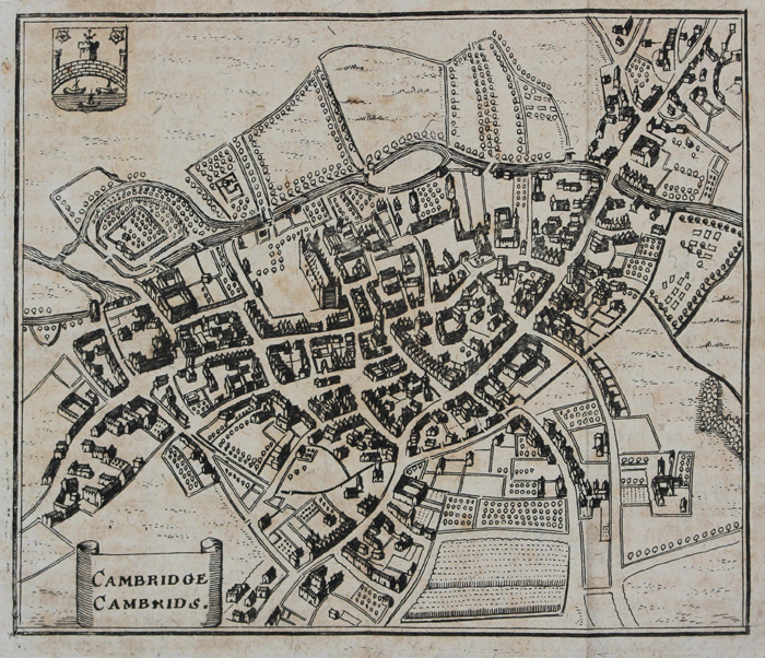
| Published | [Franckfurt-am-Mayn. In Verlegung Wilhelm Serlins. Gedruckt bey Heinrich Friesen, Anno 1666.] |
| Dimensions | 107 x 128 mm |
| Notes |
A miniature map of Cambridge from the first German edition of Hermannides' Britannia Magna, published in Frankfurt-am-Main by Wilhelm Serlin. One of the rarest and earliest town plans of Cambridge, this map is based closely on the inset town plan prepared by John Speed for his county map of Cambridgeshire. The colleges, churches, and buildings of the city are shown pictorially, in a birds-eye perspective, and, like the Speed map, features the Arms of Cambridge in the top left corner, though the boxed title is here replaced with a scroll in the bottom left. Rutger Hermannides (d.1680) was a Dutch academic, author, and cartographer. A Professor of English at the Guelders Academy, his best known work was Britannia Magna et Hibernia Nova Descriptio, an atlas of the British Isles featuring miniature maps of British cities after John Speed. Wilhelm Serlin (1625-1674) was a German bookseller and publisher, active in Frankfurt from 1649 until his death. Condition: Pressed vertical folds, as issued. Blank on verso. |
| Framing | mounted |
| Price | £300.00 |
| Stock ID | 50851 |