
| Method | Copper engraved with hand colour |
| Artist | Mercator, Gerard and Hondius, Jodocus |
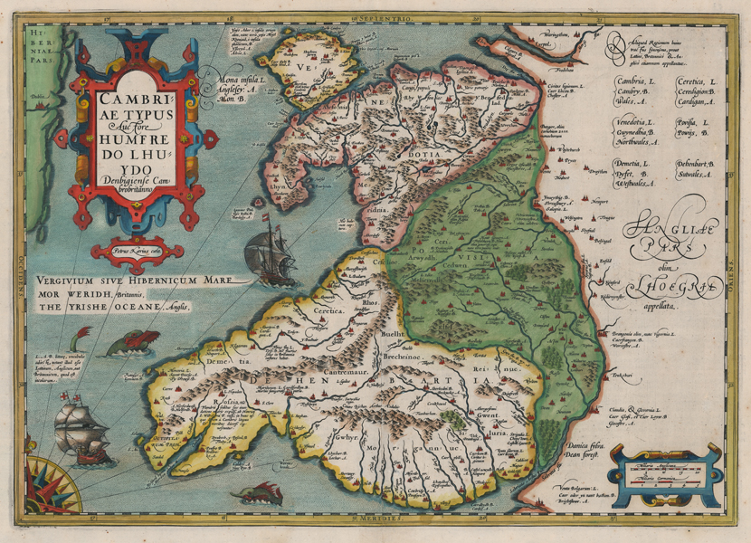
| Published | Petrus Kaerius caela. [Amsterdam, c.1606] |
| Dimensions | 350 x 490 mm |
| Notes |
A highly decorative early seventeenth century map of Wales, from Hondius' Latin printing of Mercator's Atlas Sive Cosmographicae Meditationes de Fabrica Mundi et Fabricati Figura. The map, the second printed map of Wales, was engraved by Keere as part of a suite of maps intended by Hondius to make his edition of the Mercator Atlas competitive with Ortelius' Theatrum. Ortelius' own atlas had contained the first printed map of Wales, itself based in part upon Mercator's wall map of 1564, but also from a seminal survey especially commissioned from Ortelius' friend Humphrey Llwyd. Rather than presenting Wales in its contemporary counties, a system introduced under English control, the current map divides the country into three, Venedotia (Gwynedd), Povisia (Powys), and Dehenbartia (Deheubarth), loosely preserving the ancient kingdoms of the sub-Roman period. Many of the minor kingdoms and territories, such as Ceredigion, Brycheiniog, Morgannwg, and Gwent are also featured. Regional boundaries are outlined in hand colour, Powys is shown in full and striking wash colour, and cities and towns are picked out in red. Adjoining parts of England and Ireland are also shown, with Dublin the only settlement mapped in the latter. The title, enclosed in a large strapwork cartouche, prominently cites Llwyd's contribution, following almost exactly the pattern laid out by Ortelius in his earlier map. In the Irish Sea, a pair of sailing ships avoid the attention of sea monsters, while a large ornate quarter compass rose throws rhumb lines across the water from the bottom left corner. In the blank space to the right of the map, an explanatory text provides a gloss for placenames in Latin, Welsh, and English. Gerard Mercator (1512 - 1594) originally a student of philosophy was one of the most renowned cosmographers and geographers of the 16th century, as well as an accomplished scientific instrument maker. He is most famous for introducing Mercators Projection, a system which allowed navigators to plot the same constant compass bearing on a flat map. His first maps were published in 1537 (Palestine), and 1538 (a map of the world), although his main occupation at this time was globe-making. He later moved to Duisburg, in Germany, where he produced his outstanding wall maps of Europe and of Britain. In 1569 he published his masterpiece, the twenty-one-sheet map of the world, constructed on Mercator's projection. His Atlas, sive Cosmographicae Meditationes de Fabrica Mundi, was completed by his son Rumold and published in 1595. After Rumold's death in 1599, the plates for the atlas were published by Gerard Jr. Following his death in 1604, the printing stock was bought at auction by Jodocus Hondius, and re-issued well into the seventeenth century. Jodocus Hondius (14th October 1563 - 12th February 1612) was a Dutch Flemish cartographer, engraver, and publisher. Hondius is most famous for reviving the primacy of the work of Gerard Mercator, through the publication of his Atlas, and the smaller Atlas Minor, in the early seventeenth century, at a time when cartography was largely dominated by Ortelius' Theatrum Orbis Terrarum. The Mercator-Hondius Atlas was composed of maps pulled from plates Hondius had purchased from Mercator's grandson, as well as thirty-six new plates Hondius commissioned, and in many cases engraved, himself. He is also believed to have been the chief engraver of the plates for John Speed's Theatre of the Empire of Great Britaine. Following his death, he was succeeded by his sons, Jodocus the Younger and Henricus, as well as his son in law Jan Jansson. Pieter van den Keere (1571-c.1646), also known frequently as Petrus Kaerius, came to England in 1584, as a Protestant refugee from his home town of Ghent with his sister Colette, who married Jodocus Hondius in 1587. It was probably from Hondius that Keere learned to engrave. Both engravers left London in 1593 to settle in Amsterdam. His first set of miniature maps were produced for the Middelburg publisher Cornelis Claesz, for inclusion in Barent Langenes' Caert Thresoor. Keere began to engrave a series of miniature maps in 1599 in preparation for a small atlas of the British Isles. The maps were first published in 1617 by William Blaeu with plate numbers and Latin text. They then passed to George Humble, who published them in 1619 and then again in 1627, by which time they had become known colloquially as 'Miniature Speeds.' Condition: Central vertical fold, as issued. Minor foxing to margins. Latin text on verso. Small tear to top of central fold, not affecting map. |
| Framing | unmounted |
| Price | £900.00 |
| Stock ID | 51951 |