
| Method | Copper engraved |
| Artist | Georg Braun and Frans Hogenberg |
| Published | [Cologne, c.1581] |
| Dimensions | 342 x 438 mm |
| Notes |
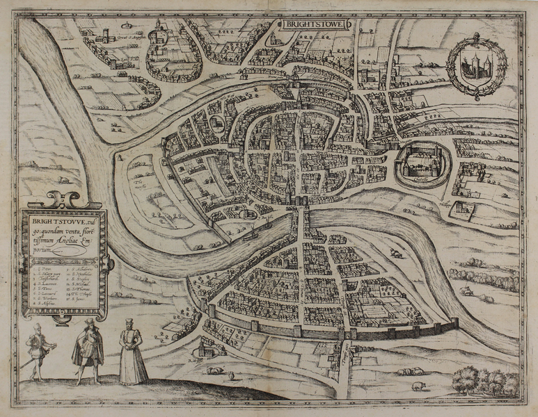
A striking city plan of Bristol in the late sixteenth century, from the third volume of Braun and Hogenberg's Civitates Orbis Terrarum. The city is shown with north-east to top, centred on the Medieval Bristol Bridge. The castle and city walls are shown in detail, and the churches of the city are labelled with a numeric key enclosed in a strapwork cartouche below the title. In the foreground are three figures in Elizabethan dress, and the Arms of the City are enclosed in a chaplet in the top right corner. Between 1572 and 1617 Georg Braun (1541-1622) and Frans Hogenberg (1535-1590) published six volumes of their Civitates Orbis Terrarum, containing over 500 prospects, views, and maps of mostly European cities, envisioned as a companion to Ortelius' atlas Theatrum Orbis Terrarum. Braun was the editor of the series, with Hogenberg as principle engraver. They relied mainly on existing cartography, but also on drawings made by the Antwerp artist Joris Hoefnagel (1542-1600), who had travelled through most of Western Europe. After Joris Hoefnagel's death his son Jakob continued the work for the Civitates. Condition: Central vertical fold as issued. Minor creasing to corners of sheet. Latin text on verso. |
| Framing | unmounted |
| Price | £700.00 |
| Stock ID | 48593 |