
| Method | Steel engraved |
| Artist | Rapkin, John |
| Published | John Tallis & Company, London & New York [c.1850] |
| Dimensions | 252 x 342 mm |
| Notes |
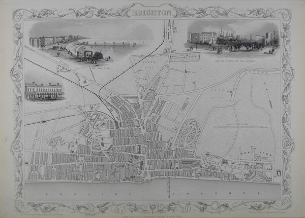
A city plan of Brighton, featuring vignettes of key attractions in the city, such as the Chain Pier, the Railway Station, and the Pavilion. Tallis maps were highly valued for their accuracy, but perhaps more so for their charming vignettes and ornamentation. Engraved by John Rapkin, these maps were praised by the New York Sun as "the most accurate and most splendid publication of the kind ever issued". The Bristol Times observed that Mr. Tallis maps "are not only critically correct, but are accompanied with elegant and appropriate engravings illustrative of the manners and costumes of the different countries." John Tallis was a British publisher and one of the most popular cartographers of the 19th Century. Tallis was renowned for his very accurate and visually attractive maps. His star engraver and map maker was John Rapkin. During the mid 19th Century, many books of travel and exploration were published by Tallis, using the extraordinary artistic and engraving skills of John Rapkin. In 1851 Tallis published his famous Illustrated Atlas. John Rapkin was an engraver and mapmaker active in Britain in the mid-nineteenth century. He drew and engraved the maps for John Tallis' The Illustrated Atlas and Modern History of the World (1845-51), which was later re-issued by the London Printing and Publishing Company. He also drew and engraved maps for R. Montgomery Martin's British Colonies, their history (1849), and Wright's Universal Pronouncing Dictionary (c.1850). Condition: Some light discolouration to sheet. |
| Framing | unmounted |
| Price | £200.00 |
| Stock ID | 39604 |