
| Method | Copper engraved with hand colour |
| Artist | Ortelius, Abraham |
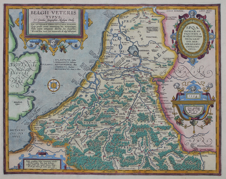
| Published | Ex Conatibus Geographicis Abrahami Ortelij. 1594. Cum privilegio Imperiali et Belgico, ad decennium. [1603 Parargon] |
| Dimensions | 378 x 490 mm |
| Notes |
A map of ancient Belgium, usually refereed to as Belgica and considered a part of Gaul by classical authors, from the 1603 Latin edition of the Parergon (Supplement) of Ortelius' famous Theatrum Orbis Terrarum. The map depicts the ancient Celtic regions of Ortelius' homeland, divided according to tribal territories, and densely covered in forest, as well as the east coast of Britain, inhabited, according to Caesar, by Belgic tribes. Principle cities and towns are picked out in red. The names of many settlements also appear alongside pertinent references from the classical source tradition. Indeed all place-names that are featured on the map have had their names recorded according to their age and origin. The oldest names, of Celtic tribes and settlements, are recorded in Latin capitals, while younger Roman titles are given in lower case. Those names that are not featured in the classical sources are rendered in cursive, while relevant modern titles are given in a stylised Germanic cursive. The map is heavily annotated with points of cartographic and historic interest. Places of uncertain location are listed above the cartouche at the top right corner, while classical remains, many of which were explored by Ortelius himself, are depicted, including a 'Barbarian' altar, a bridge supposedly built by Julian the apostate, the camps of Cicero and the German legions, numerous temples, and a coastal beacon or lighthouse established by Charlemagne. Ortelius evidently took great pride in this map of his home country, as the four large decorative cartouches feature numerous laudatory remarks about the Low Countries, and Ortelius himself. In the bottom left corner, a strap-work box cartouche encloses four poetic lines penned by Ortelius friend Hugo Favolius, urging the Belgian race to reconnect with their antique past. In the top right, an oval cartouche dedicates the map to the Senate and People of Antwerp, and commenting on the sweet hold the native soil has on the cartographer himself. This is the second state of Ortelius' map of ancient Belgium, which differs from the original only in the date given in the top of the privilege cartouche to the right. The first state is marked as '1584.' This example reads '1594.' The Parergon ('Supplement') was, as the title suggests, originally conceived of as a supplement to Ortelius' Theatrum. The work, a massive and intricately researched index of the classical world, was accompanied by a series of ancient world maps. Unlike the maps of the Theatrum, the majority of which were reductions of earlier maps, the maps of the Parergon were researched and drawn by Ortelius himself. The work was a huge commercial success, and the maps themselves set the standard for ancient world maps for the duration of the seventeenth century, being reproduced or reprinted by various publishers after Ortelius' final 1624 printing. His interest in the mapping of the ancient world is manifest. The maps of the Parergon are a veritable mine of textual commentary and classical philology, drawing upon Ptolemy, Strabo, Pliny, and many others. Interestingly, the project seems to have been a labour of love, rather than a mercantile venture. Ortelius himself was fascinated with the ancient world, and a formidable classical scholar in his own right. In addition to his work as a cartographer, he dealt in antiquities, visited and surveyed ancient sites across Europe, published a critical edition of Caesar's Gallic Wars in 1593, and assisted Welser in his studies of the famous Tabula Peutingeriana in 1598, producing an engraved copy of the map that can be found in later editions of the Parergon. Abraham Ortelius (1527 -1598) was a Flemish cartographer, cosmographer, geographer and publisher and a contemporary of Gerard Mercator, with whom he travelled through Italy and France. Although it is Mercator who first used the word "Atlas" as a name for a collection of maps, it is Ortelius who is remembered as the creator of the first modern atlas. Theatrum Orbis Terrarum was the first systematically collated set of maps by different map makers in a uniform format. Three Latin editions as well as a Dutch, French and German edition of Theatrum Orbis Terrarum were published by 1572 and a further 25 editions printed before Ortelius' death in 1598. Several more were subsequently printed until around 1612. Ortelius is said to have been the first person to pose the question of the continents once being a single land mass before separating into their current positions. Condition: Clean, crisp impression with full margins, presented in full wash colour. Central vertical fold as issued. Minor time toning to edges of sheet, not affecting map or plate. Latin text on verso. |
| Framing | unmounted |
| Price | £675.00 |
| Stock ID | 51186 |