
| Method | Copper engraved with early hand colour |
| Artist | Schenk, Pieter and Valk, Gerard after Jansson, Jan |
| Published | Prostant Amstelaedami apud Petrum Schenk et Gerardum Valk. C.P. [Amsterdam, c.1694] |
| Dimensions | 440 x 510 mm |
| Notes |
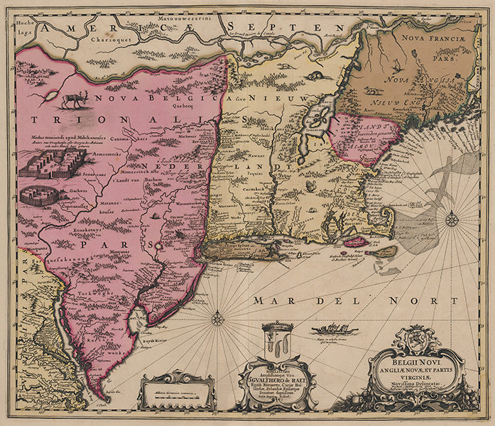
One of the most historically significant and detailed maps of New England, here presented in beautiful full wash colour in the third state, issued by Schenk and Valk from the original Jansson plate. The map covers the north eastern coast of North America from Quebec City in the north to the Chesapeake Bay region in the south. The map is replete with detail, making it the most accurate map of the region from the era. Jansson also shows an impressively universal approach in his cartography, plotting Dutch, English, Swedish, and indigenous place names without preference or political motive, at a time of intensifying colonial ambitions in the region. The mapping of Manhattan and Long Island in particular are of note, with Nieuw Amsterdam (New York) clearly legible. Many other now-recognisable placenames are also shown, including Breukelen (Brooklyn), Stamfort (Stamford), Nieuhaven (Newhaven), Milfort (Milford), Marthaes Vyneard (Martha's Vineyard), and Neu Playmont (Plymouth). Notable by its absence is Boston, perhaps an indicator of Jansson's lack of access to detailed knowledge of the rapidly expanding English influence in Massachusetts. Swedish settlements along the Delaware, by contrast, are much better known. In the north, attempts have also been made to map parts of the Great Lakes, and Lake Champlain is shown in some detail. The map is further embellished by numerous vignettes of native wildlife, including a beaver, turkey, elk, a pair of wolves or coyotes, and an opossum. In the top left, a pair of 'Mohican' villages are likely based upon the earlier map of the region by Blaeu, whose ultimate source were illustrations by de Bry. Similarly a large war canoe off the southern coast of Cape Cod features a note that it was crafted by burning the core out of a tree trunk, a technique described by de Bry as being in use throughout the Americas. Off the eastern coast of New England, large shoals are shown alongside a compass rose radiating rhumb lines. The map, described by Burden as one of the 'fundamental prototypes' for the mapping of America in the seventeenth century, was separately issued in 1651 before its inclusion in its second state in editions of the Jansson Atlas Novus from the 1660s. The very rare first state featured two of the three cartouches seen here, the scale in German miles and the baroque title cartouche surmounted by the Arms of the Dutch Republic. For the second state, a third cartouche was added between the earlier two, featuring a dedication to Gualter de Raedt, Knight Baronet. In 1694, the plates for Jansson's Atlas Major were bought by Schenk at auction from Jansson's son-in-law, Jan Jansson van Waesbergen, and the third state, as here, was altered to feature the impressum of Schenk and Valk. Johannes Janssonius (1588 - 1664) was a famed cartographer and print publisher. More commonly known as Jan Jansson, he was born in Arnhem where his father, Jan Janszoon the Elder, was a bookseller and publisher. In 1612 he married the daughter of the cartographer and publisher Jodocus Hondius, and then set up in business in Amsterdam as a book publisher. In 1616 he published his first maps of France and Italy and from then onwards, produced a very large number of maps which went some way to rival those of the Blaeu family, who held a virtual monopoly over the industry. From about 1630 to 1638 he was in partnership with his brother-in-law, Henricus Hondius, issuing further editions of the Mercator/Hondius atlases to which his name was added. On the death of Hondius he took over the business, expanding the atlas still further, until eventually he published an eleven volume Atlas Major on a scale similar to Johannes Blaeu's magnum opus. After Jansson's death, his heirs published a number of maps in the Atlas Contractus of 1666, and, later still, many of the plates of his British maps were acquired by Pieter Schenk and Gerard Valck, who published them again in 1683 as separate maps. Petrus Schenk (1660-1715) was born in Germany but moved to Amsterdam where he studied engraving with Gerard Valck. He had two shops where he sold maps and prints, one in Amsterdam and the other in Leipzig. This plate is from Schenk's early town atlas which depicted 100 cities on four continents. Gerald Valk (1652 -1726) was a Dutch publisher, globe maker, art seller and engraver. He trained under Abraham Bloteling, later becoming his assistant. The pair moved to London in 1672 where Valk worked with David Loggan and Christopher Browne. Gerard married Maria, Bloteling's daughter, and in 1675 their son, Leonard, was born. Burden 305 iii/iii Condition: Central vertical fold, as issued. Some creasing to central fold. Minor time toning to edges of sheet. Acid burns, verdigris from old colour, and manuscript pagination to verso, otherwise blank. |
| Framing | unmounted |
| Price | £4,000.00 |
| Stock ID | 53429 |