
| Method | Copper engraved |
| Artist | Speed, John |
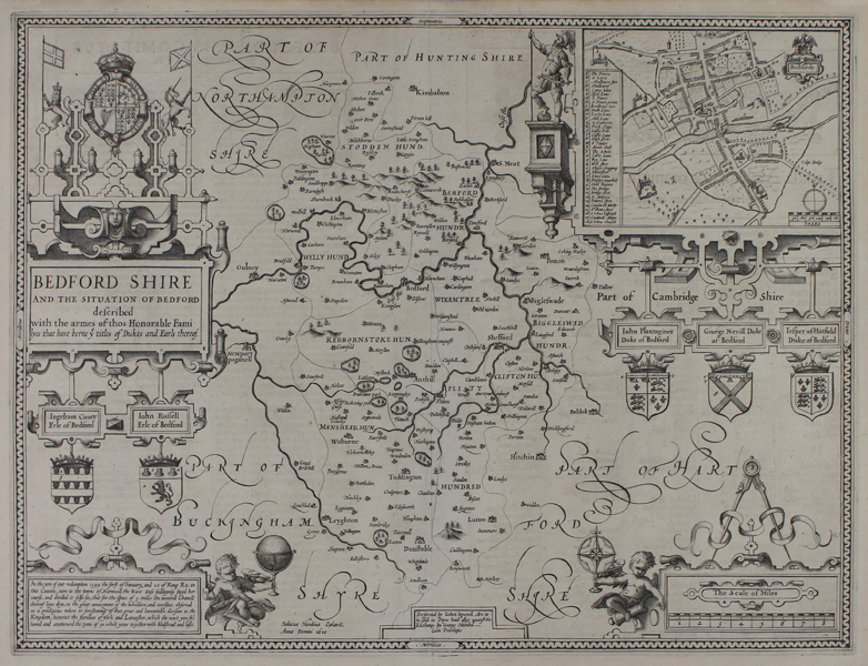
| Published | Jodocus Hondius Caelavit. Anno Domini 1610. Performed by Iohn Speed, Are to be sold in Popes head alley against the Exchange by George Humbel, Cum Privilegio [c.1611] |
| Dimensions | 382 x 510 mm |
| Notes |
John Speed's first edition decorative map of the county of Bedfordshire, from the celebrated Theatre of the Empire of Great Britaine. A detailed plan of Bedford is featured in the upper right corner, with a lettered key. The elaborate strapwork around the inset town plan features the coats of arms for the Dukes of Bedford, and a plinth to the left of the map supports a warrior in classical dress. Along the left hand side, a large decorative strapwork cartouche encloses the title, as well as providing a further two crests for the Earls of Bedford and the Gartered Arms of the United Kingdom between a lion and unicorn. In the bottom corners of the plate, a pair of further cartouches contain a scale in miles, and a lengthy note about a miraculous occurrence in 1399 in which the River Ouse stayed its course and then split in two as a 'prodigious token or foreshewing' of the schism of the Houses of York and Lancaster. Latin text on verso describing the county, accompanied by a list of Berkshire's hundreds, and an alphabetical list of place names. John Speed (1552-1629) is the most famous of all English cartographers primarily as a result of The Theatre of the Empire of Great Britaine, the first atlas of the British Isles. The maps from this atlas are the best known and most sought-after of all county maps. The maps were derived mainly from the earlier prototypes of Christopher Saxton and John Norden but with notable improvements including parish "Hundreds" and county boundaries, town plans and embellishments such as the coats of arms of local Earls, Dukes, and the Royal Household. The maps are famed for their borders consisting of local inhabitants in national costume and panoramic vignette views of major cities and towns. An added feature is that regular atlas copies have English text printed on the reverse, giving a charming description of life in the early seventeenth century of the region. The overall effect produced very decorative, attractive and informative maps. For the publication of his prestigious atlas, Speed turned to the most successful London print-sellers of the day, John Sudbury and George Humble. William Camden introduced the leading Flemish engraver, Jodocus Hondius Sr. to John Speed in 1607 because first choice engraver William Rogers had died a few years earlier. Work commenced with the printed proofs being sent back and forth between London and Amsterdam for correction and was finally sent to London in 1611 for publication. The work was an immediate success, with the maps themselves being printed for the next 150 years. Speed was born in 1552 at Farndon, Cheshire. Like his father before him he was a tailor by trade, but around 1582 he moved to London. During his spare time Speed pursued his interests of history and cartography and in 1595 his first map of Canaan was published in the "Biblical Times". This raised his profile and he soon came to the attention of poet and dramatist Sir Fulke Greville a prominent figure in the court of Queen Elizabeth. Greville as Treasurer of the Royal Navy gave Speed an appointment in the Customs Service giving him a steady income and time to pursue cartography. Through his work he became a member of such learned societies as the Society of Antiquaries and associated with the likes of William Camden, Robert Cotton, and William Lambarde. He died in 1629 at the age of seventy-seven. Condition: Central vertical fold as issued. Minor paper thinning and printer's creases to sheet. Minor tears and creasing to margins, not affecting map. |
| Framing | unmounted |
| Price | £750.00 |
| Stock ID | 50773 |