
| Method | Copper engraved |
| Artist | Cole, Benjamin |
| Published | London: Printed for T. Osborne and J. Shipton, in Gray's-Inn; and J. Hodges, near London-Bridge, 1756. |
| Dimensions | 354 x 474 mm |
| Notes |
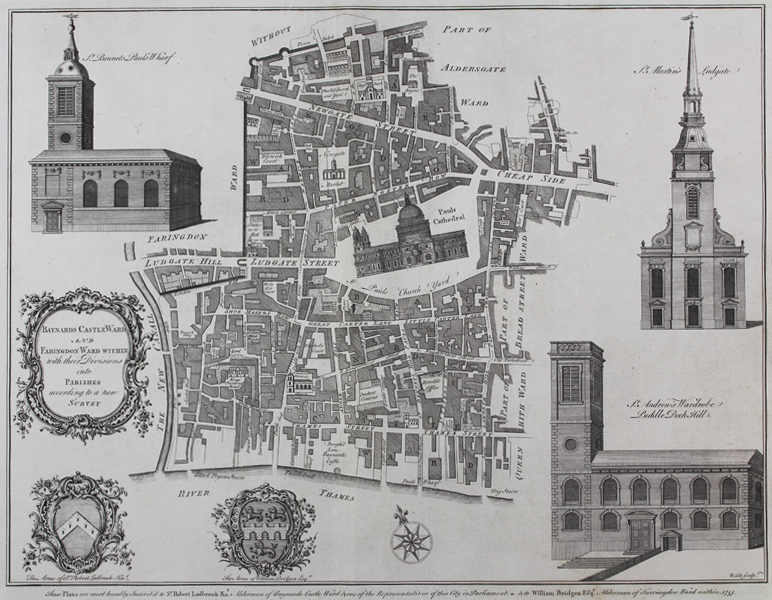
A map of Baynards Castle and Fraringdon Ward from William Maitland's The History and Survey of London from it's Foundation to the Present Time centred around St. Pauls cathedral , with the Thames to the south and Newgate and Cheapside to the North, engravings of St. Bennets Pauls Wharf, St. Martin's Ludgate and St Andrew's Wardrobe Puddle Dock Hill Churches flank the plan. A decorative title cartouche and the arms of Sir Robert Ladbrook and William Bridgen to the left and below. The inscription below the plan reads: These Plans are most humbly Inscrib'd to Sir Robert Ladbrook Knt. Alderman of Baynards Castle Ward & one of the Representatives of this City in Parliament - & to William Bridgen Esqr Alderman of Farringdon Ward within 1755. Benjamin Cole (1697-1783) was an English printmaker, who engraved, printed and sold prints from his shop at St Paul's Church in London. He also produced a wide variety of book illustrations, and is not to be confused with the near contemporary map engraver of the same name (1667-1729), who was active in Oxford. Condition: Vertical folds as issued. |
| Framing | unmounted |
| Price | £280.00 |
| Stock ID | 49939 |