
| Method | Chromolithograph |
| Artist | Bartholomew, John |
| Published | The Geographical Institute Edinburgh. Copyright - John Bartholomew & Son, Ltd. [Edinburgh, c.1950] |
| Dimensions | 620 x 920 mm |
| Notes |
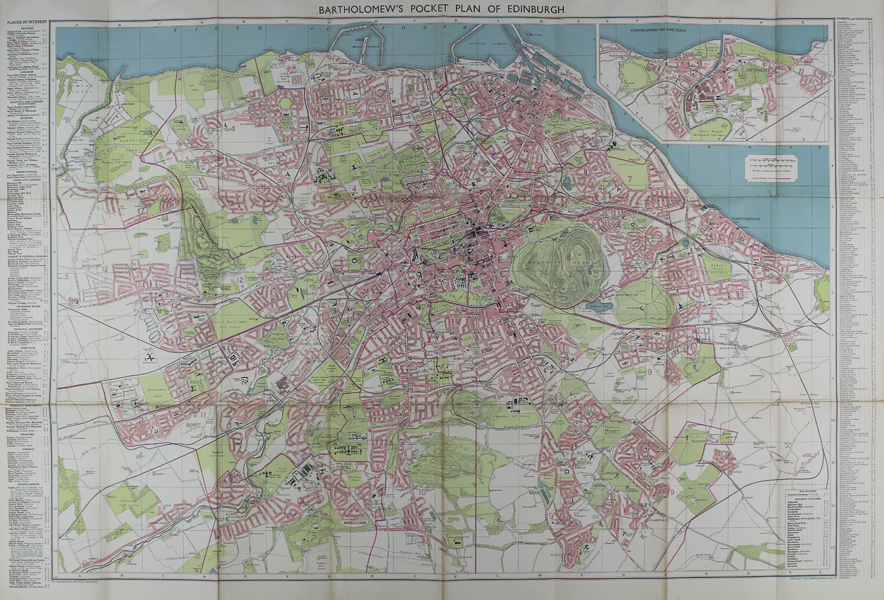
A large and detailed mid-twentieth century street map of Edinburgh, published by John Bartholomew & Son Ltd. The map stretches south almost as far as the modern day bypass, and the coastline east of Portobello is continued in an inset map in the top right corner of the sheet. Streets are shaded in pink, and public parks and arable land are marked in green. Public amenities and historic buildings are given black footprints, and the topography of Holyrood Park, Corstorphene Hill, and the Braid Hills is also marked. Railways are marked with a corresponding key. The acronyms of the various rail companies, which appear on earlier editions pre-dating nationalization, have been removed. In the left and right margins, a long list provides an index of 'Streets and Localities.' John Bartholomew & Son was founded by John Bartholomew Senior (1805 - 1861) in 1826. Initially the firm printed maps for external companies, though under John Bartholomew Junior and his son John George Bartholomew, the company achieved much greater success after making the decision to commission and print their own map series. In particular, the firm was responsible for the Times Survey Atlas of the World (1922) and successive Times Atlases. Condition: Horizontal and vertical folds as issued. Backed on cloth as issued, with some wear and discolouration to folds. Faced on two verso panels with original covers, featuring the Arms of the City of Edinburgh. |
| Framing | unmounted |
| Price | £100.00 |
| Stock ID | 48649 |