
| Method | Copper engraved with hand colour |
| Artist | Ortelius, Abraham |
| Published | Cum Privilegio [Antwerp, 1595] |
| Dimensions | 330 x 500 mm |
| Notes |
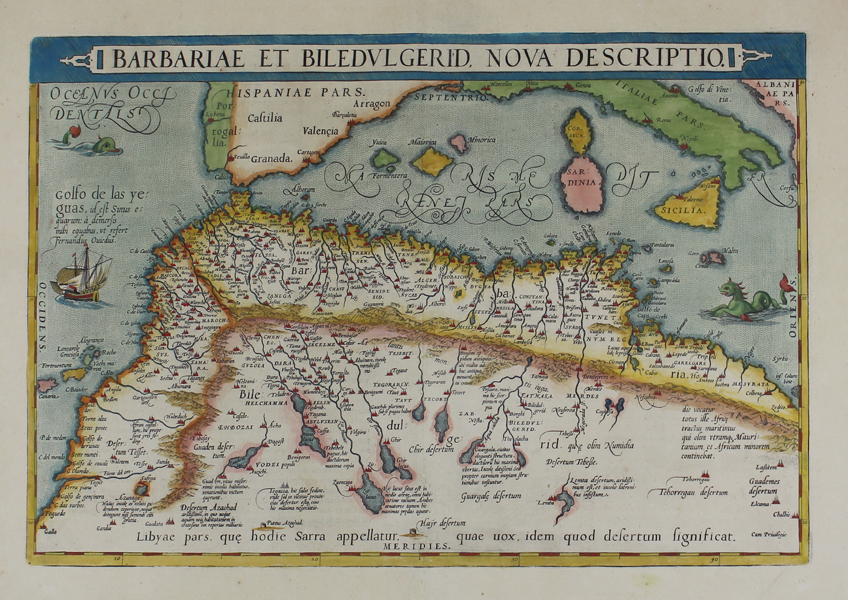
A beautiful sixteenth century map of north Africa, from the 1595 Latin edition of the famous Theatrum Orbis Terrarum. The map covers the regions of Barbaria and Biledulgerid, essentially the territories north and south of the Atlas mountains, today divided into the countries of Algeria, Tunisia, and Libya. Morocco is shown as a separate kingdom, and the adjoining parts of southern Europe can also be seen, including Portugal, Spain, the Balearics, Corsica, Sardinia, Sicily, Italy, and Malta. The various lakes and oases of the Atlas hinterland are shown pictorially, and a large text label below indicates the Sahara. Cities and towns are picked out in red, and the Mediterranean and Atlantic are populated by a sailing ship and two large sea monsters. Abraham Ortelius (1527 -1598) was a Flemish cartographer, cosmographer, geographer and publisher and a contemporary of Gerard Mercator, with whom he travelled through Italy and France. Although it is Mercator who first used the word "Atlas" as a name for a collection of maps, it is Ortelius who is remembered as the creator of the first modern atlas. Theatrum Orbis Terrarum was the first systematically collated set of maps by different map makers in a uniform format. Three Latin editions as well as a Dutch, French and German edition of Theatrum Orbis Terrarum were published by 1572 and a further 25 editions printed before Ortelius' death in 1598. Several more were subsequently printed until around 1612. Ortelius is said to have been the first person to pose the question of the continents once being a single land mass before separating into their current positions. Condition: Central vertical fold as issued. Repaired puncture to central fold. Latin text on verso. |
| Framing | unmounted |
| Price | £600.00 |
| Stock ID | 46786 |