
| Method | Copper engraved |
| Artist | Mercator, Gerard |
| Published | [François Halma, Utrecht, c.1695] |
| Dimensions | 345 x 322 mm |
| Notes |
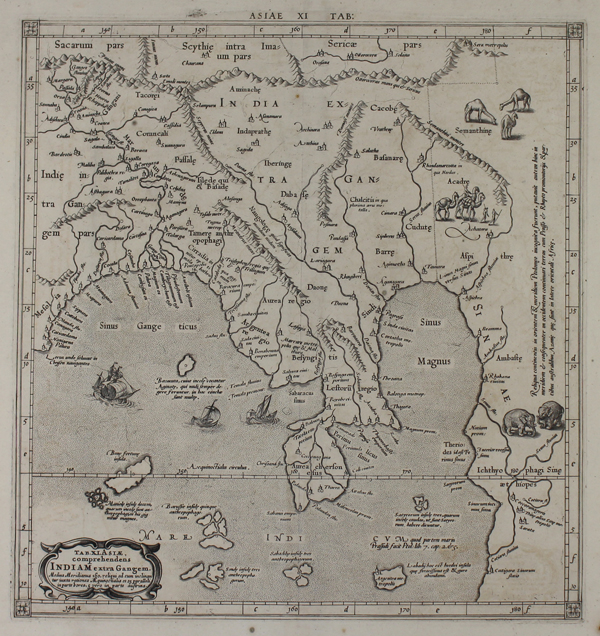
A finely engraved, decorative map of India beyond the Ganges, the classical name for the northwestern part of southeast Asia, based on Ptolemy's ancient map of the region. The region shown covers most of modern day Bangladesh and Myanmar, with adjoining parts of India and China. The area of the Yangon peninsula is labelled 'Aurea Chersonesus' in reference to the abundant gold that classical cartographers believed issued forth from its ports. A large annotation running along the right edge of the map describes this as the limits of geographic knowledge in the classical west. Camels, both wild and being led by merchants, are included north of the Gulf of Martaban, and a pair of elephants are shown on the southern coast of Myanmar, while sailing ships ply the waters near the mouths of the Ganges. Mercator's edition of the Geographia retained the details of Ptolemy's ancient cartography but updated the plates with contemporary decorative elements. The atlas was initially published in 1578, reissued by Petrus Bertius in 1618 as part of his 'Theatrum Geographiae Veteris', before the plates were sold to François Halma, who reengraved the title cartouches for his 1695 Claudii Ptolemaei Tabulae Geographicae Orbis Terrarum Veteribus cogniti. This particular example is the second state Halma printing, with the original strapwork cartouche replaced by a baroque oval bearing the following inscription: TAB XI ASIAE, comprehendens Indiam extra Gangem. Medius Meridianus 160 reliqui ad eum inclinantur iuxta rationes Aequinoctialis et 25 paralleli in parte borea, 5 vero in parte austrina. Gerard Mercator (1512 - 1594) originally a student of philosophy was one of the most renowned cosmographers and geographers of the 16th century, as well as an accomplished scientific instrument maker. He is most famous for introducing Mercators Projection, a system which allowed navigators to plot the same constant compass bearing on a flat map. His first maps were published in 1537 (Palestine), and 1538 (a map of the world), although his main occupation at this time was globe-making. He later moved to Duisburg, in Germany, where he produced his outstanding wall maps of Europe and of Britain. In 1569 he published his masterpiece, the twenty-one-sheet map of the world, constructed on Mercator's projection. His Atlas, sive Cosmographicae Meditationes de Fabrica Mundi, was completed by his son Rumold and published in 1595. After Rumold's death in 1599, the plates for the atlas were published by Gerard Jr. Following his death in 1604, the printing stock was bought at auction by Jodocus Hondius, and re-issued well into the seventeenth century. Ptolemy (c. AD 100-170) was a Greek native of the Egyptian city of Alexandria, and a Roman citizen. Little is known about his life, but he is credited as the author of numerous works of mathematics, engineering, astronomy, astrology, philosophy, and geography. His most famous works were the Almagest, the Geography, and the Tetrabiblion, a triad that essentially formed the basis of Byzantine, Arabic, and European science for the next thousand years. The Geography in particular had a very long reach, being reprinted numerous times in the fifteenth and sixteenth centuries. Its most famous advocate was Columbus, who used a manuscript of the Geography to plot his western course for Asia, in the journey that resulted in the discovery of America. The work was also a major inspiration, and cartographic resource, for Munster, Mercator, and Ortelius. Condition: Central vertical fold, as issued. Small tear to bottom of central fold, not affecting map. Minor time toning and foxing to sheet. Manuscript '17' in old hand on verso, otherwise blank. |
| Framing | unmounted |
| Price | £425.00 |
| Stock ID | 50705 |