
| Method | Copper engraved with hand colour |
| Artist | Blaeu, Willem Janszoon |
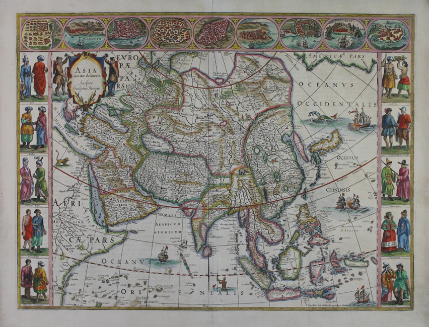
| Published | Auctore Guiljelmo Blaeuw. Cum Illust. Ord. Hollandiae privilegio decennali. [Amsterdam, 1635] |
| Dimensions | 408 x 548 mm |
| Notes |
A beautiful example of one of Blaeu's famous carte-a-figures maps, the current map depicting the continent of Asia. Blaeu's carte-e-figures maps of the world and the four continents are some of his most desirable. Reduced versions of the set of five wall maps he published in 1608, each example features a border of vignettes of principal cities, as well as depictions of pairs of figures in the national dress of the kingdoms and races of each continent. This particular example is from the 1635 Nieuwe Atlas, a Dutch printing of the Atlas. In the current example, the continent of Asia is shown, with adjoining sections of Africa and Europe, and with the westernmost reaches of North America visible at the top right corner of the map. The borders of the various empires and nations of Asia are outlined in hand colour, and principal cities are picked out in red, as is the path of the Great Wall, separating a slightly truncated China from the lands of Tartaria. On the Tartar side of the wall, a nomad leads a Bactrian camel, and an elephant runs across a river delta to the east of India, roughly equivalent with modern day Bhutan and Bangladesh. A lion fills the desert to the west of the Nile River. The Arabian peninsula is divided into Arabia Deserta and Arabia Felix, and the Persian empire stretches from the Gulf to the banks of the Ganges. In the far east, Korea is shown as an island, rather than a peninsula, and Japan retains the horizontal orientation typical of maps of this era, following the surveys of Luis Teixeira, and the map of Ortelius. A number of the islands of the South East Asian archipelago are still unmapped, or only partially depicted, most notably Borneo, Java, and the Celebes. New Guinea is absent, as are any suggestions of the top of Australia, though the island of Ceiram probably represents the northwest Papuan seacoast. The seas of the Pacific and Indian oceans feature numerous sailing ships and sea monsters, the most notable of which is a horned triton, who blows a horn in the sea between Sumatra and the Maldives. At the top left corner, the title is enclosed in a baroque cartouche featuring a stag's head, and supported by a pair of northern Asian nomads, possibly Tartars or Bactrians. The highly decorative borders feature vignettes of Candy (Kandy, Sri Lanka), Calecuth (Kolkata), Goa, Damasco (Damascus), Jerusalem, Ormus (Hormuz), Bantam (Banten, near Jakarta), Aden, and Macao (Macau), while pairs of figures represent the costumes of Syrians, Arabs, Armenians and Persians, Indians, Sumatrans, Javanese, Moluccans, Chinese, Moscovites, and Tartars. The Blaeu family were one of the most famous publishers of maps, globes and atlases during the seventeenth-century. Cartographers, globe makers and booksellers, the Blaeu business flourished in Amsterdam for over 40 years, until a fire destroyed their premises in 1672. They lost all of their plates, prints and stock, which effectively ruined the firm. Willem Blaeu founded the business in 1596. It initially functioned as a globe and instrument makers, but soon expanded into maps, topography and sea charts. The Atlas Novus was Willems great work; a major work which intended to include the most up-to-date maps of the entire world. He issued the first two volumes in 1635, but died in 1638 before the atlas was completed. The running of the business was passed on to his sons Johannes and Cornelius, in addition to the role of the official cartographer of the East India Company. After the death of Cornelis in 1644, Johannes continued the business alone and established his own reputation as a great mapmaker. Johannes completed his father's grand project in 1655 with the sixth and final volume of the Atlas Novus. He also produced the Tooneel der Steden van der Vereenighde Nederlanden in 1649-1653, as well as a similar set of Italian town plans which were published in 1663. Condition: Pressed central vertical fold, as issued. Tears to right corner of top edge and top corner of left edge of sheet, not affecting map. Strong impression with full margins. Dutch text on verso. |
| Framing | framed |
| Price | £3,750.00 |
| Stock ID | 50976 |