
| Method | Copper engraved |
| Artist | Visscher, Nicolas |
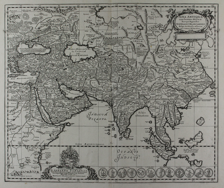
| Published | Nicolaus Blancardus Belga, Leidensis, ad lucem aevi veteris delineabat. [Amsterdam, c.1655] |
| Dimensions | 460 x 550 mm |
| Notes |
A large and finely engraved seventeenth century map of Asia, as known in the classical era, designed by Nicolaas Blankaart, a Dutch scholar of Greek, for Jansson's Accuratissma Orbis Antiqui Delineatio Sive Geographia Vetus, Sacra, et Profana, a supplement to his Atlas Novus, featuring classical and biblical maps. The general details of the map follow contemporary, rather than ancient, geography, though place names and regions are largely given following Ptolemy, Strabo, and others. China is somewhat truncated, as is Borneo, and the Philippines is shown as a single island. Perhaps the most striking cartographic quirk is the location of the Ganges, the Delta of which opens onto the South China Sea rather than the Bay of Bengal. Perhaps, as the Ganges was seen as the limit of classical knowledge of Asia, this was a cartographic conceit to allow the inclusion of south-east Asia, particularly in the case of Sumatra, which Blankaart has here equated with Taprobana, unlike the conventional Ptolemaic identification of Taprobana as Sri Lanka. The map is further ornamented with a baroque title cartouche, though the publication space is left uninscribed, and a very decorative dedication to Gerard Schaep, Consul of Amsterdam, and former Legate of the King of Denmark. Along the bottom right of the plate, six pairs of illustrations show Roman Imperial coinage relating to conquests in Asia, by Antoninus, Hadrian, Lucius Verus, Vespasian and Titus, and Trajan. The Visscher family produced maps and atlases in Amsterdam throughout the seventeenth and early eighteenth century. Established by Claes Janszoon Visscher (1587-1652), they mainly published atlases from plates purchased from Pieter van den Keere. The business was then continued by Claes' son Nicolas Visscher I (1618-1679) and his grandson Nicolas II. The Visschers published many revised editions of their 'Atlas Contractus' and 'Atlas Minor'. Upon the death of Nicholas II, his wife, Elizabeth, continued the business before selling it to Pieter Schenk. Johannes Janssonius (1588 - 1664) was a famed cartographer and print publisher. More commonly known as Jan Jansson, he was born in Arnhem where his father, Jan Janszoon the Elder, was a bookseller and publisher. In 1612 he married the daughter of the cartographer and publisher Jodocus Hondius, and then set up in business in Amsterdam as a book publisher. In 1616 he published his first maps of France and Italy and from then onwards, produced a very large number of maps which went some way to rival those of the Blaeu family, who held a virtual monopoly over the industry. From about 1630 to 1638 he was in partnership with his brother-in-law, Henricus Hondius, issuing further editions of the Mercator/Hondius atlases to which his name was added. On the death of Hondius he took over the business, expanding the atlas still further, until eventually he published an eleven volume Atlas Major on a scale similar to Johannes Blaeu's magnum opus. After Jansson's death, his heirs published a number of maps in the Atlas Contractus of 1666, and, later still, many of the plates of his British maps were acquired by Pieter Schenk and Gerard Valck, who published them again in 1683 as separate maps. Condition: Central vertical fold as issued. Binders crease to left and right of central fold. Small insect holes to top margin, not affecting map. Blank on verso. |
| Framing | unmounted |
| Price | £700.00 |
| Stock ID | 45793 |