
| Method | Copper engraved with original hand colour |
| Artist | d'Anville, Jean Baptiste Bourguignon |
| Published | London. Published by Laurie & Whittle, No. 53, Fleet Street. 12th May 1794 |
| Dimensions | 1030 x 1200 mm |
| Notes |
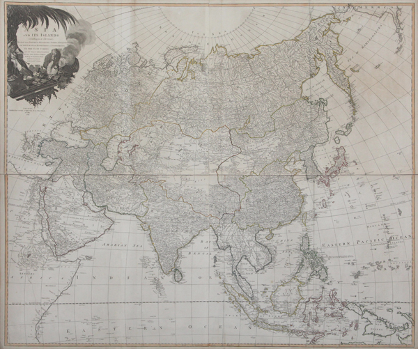
An impressive and very large wall map of the continent of Asia, following d'Anville and printed over four sheets by Laurie & Whittle for Kitchin's General Atlas, describing the Whole Universe: being a complete collection of the most approved maps extant; corrected with the greatest care, and augmented from the last edition of D'Anville and Robert with many improvements by other eminent geographers. The map spans the entirety of the Asian continent, from Turkey and the Arabian Peninsula in the West to Japan, New Guinea, and the islands of the Pacific in the East. At the far left, the eastern coast of Africa can be seen, while at the extreme top right, parts of Alaska and Canada are depicted. In the bottom right corner, the coastline of Papua New Guinea is mapped completely, though erroneously. The northernmost reaches of Australia are labelled as 'part of New Holland.' The map is covered in notes of geographic interest. In the Arabian Peninsula, a note warn about the 'very dry deserts' encountered between Mecca and the Persian Gulf. The site at which Admiral Anson captured the Manilla Galleon is marked, and a site at the northern tip of Borneo is labelled cryptically as 'Pyrates Point.' Above the tip of Cape York, 'Endeavour's passage' marks the journey of Cook. The map is outlined in original hand colour, and further ornamented by a large oriental cartouche in the top left corner, which features a Turk with a long pipe under a large palm tree and a camel resting beside a smoking incense burner. Full title reads: Asia and Its Islands according to D'Anville: Divided into Empires, Kingdoms, States, Regions, &c. with the European Possessions and Settlements in the East Indies and an Exact Delineation of All the Discoveries made in the Eastern Parts by the English under Captn. Cook. Jean Baptiste Bourguignon d'Anville (11th July 1697 - 28th January 1782) was a French cartographer, geographer, and antiquarian, whose rigourous standards of geographic reference revolutionised map making during the latter half of the eighteenth century. Rather than rely on the authority of earlier cartographers in the creation of his maps, d'Anville insisted on verifiable evidence. The resulting maps looked vastly different from the work of his predecessors. Ornamentation was stripped back, and dubious locations were simply left blank. In 1754 he became a member of the Académie des Inscriptions et Belles Lettres, and in 1775 was appointed first geographer to King Louis XVI. Robert Laurie (c.1755-1836) was a British engraver, mezzotint artist, and publisher. In 1776, he was awarded a prize by the Society of Arts for the invention of a method of producing colour-printed mezzotints. Laurie succeeded the publisher Robert Sayer after the latter's death in 1794, and, in partnership with James Whittle, continued Sayer's prolific and well-established business on the Fleet Street, issuing prints, maps, illustrated books, charts, and nautical works. Following Laurie's retirement in 1812, Whittle continued in business with his former partner's son, Richard Holmes Laurie, who gained sole ownership of the business in 1818 with the death of Whittle. Condition: Printed over four sheets, folded and joined as issued. Original outline colour. Minor tears to folds. Minor time toning to edges of sheet, not affecting map. |
| Framing | unmounted |
| Price | £2,500.00 |
| Stock ID | 43626 |