
| Method | Copper engraved |
| Artist | Ortelius, Abraham |
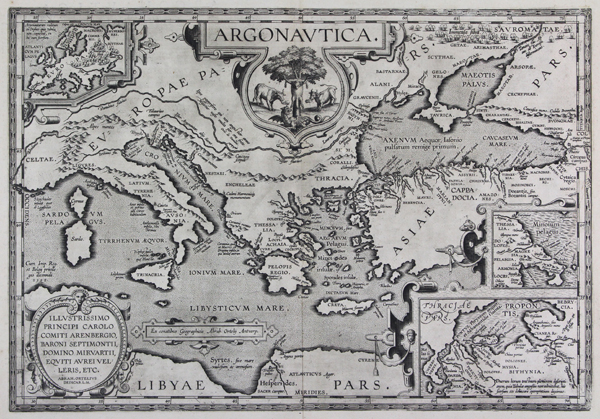
| Published | Ex conatibus Geographicis Abrah. Ortelij Antverp. [1601 Parergon edition] |
| Dimensions | 340 x 490 mm |
| Notes |
A stunning first edition printing of Ortelius' map of the journeys of Jason and the Argonauts, from the 1601 Parergon (Supplement) of the Theatrum Orbis Terrarum. The map, a partner to Ortelius' celebrated map of the voyages of Aeneas, shows the Mediterranean and Black Sea with specific reference to the path of the Argo, mainly following the timeline and geography of Apollonius of Rhodes' Argonautica. The map is heavily annotated with references and verses from the classical corpus, plotting the key points from Jason's travels, as well as the various tribes, peoples, and nations of the Greek, Scythian, and North African worlds. Many of the myth's more fantastical elements are also plotted, including the Symplegades or 'Wandering Rocks' at the Bosporus mouth of the Black Sea, the monsters Scylla and Charybdis on either side of the Straits of Messina, the island of Aeaea home of the witch Circe off the Neapolitan coast, the island of the nymph Calypso off the southern Calabrian coast, the paradisiacal Garden of the Hesperides on the northern coast of Africa, and the cities of Colchis on the Black Sea, home of Jason's future wife Medea and the famous Golden Fleece. The River Danube is described, with reference, to Ovid, as 'papyriferous,' while the Tanais, in the lands of the savage Sauromatae, is explained to be the division between the Ptolemaic continents of Europa and Asia. The map is further embellished by a series of decorative strapwork cartouches. The title, at top centre, is emblazoned above a vignette depicting the Golden Fleece hung on a tree. The guardian serpent Drakon lies menacingly below. To either side of the tree, a pair of fire-breathing bulls stand guard, representative of those that Jason was required to use to sow a field of dragon's teeth, as part of the trial set for him by Aeetes, child of the sun and King of Colchis. At bottom left, an oval cartouche encloses a dedication to Carolus, Duke of Arenberg and Knight of the Golden Fleece. The final two, in the top left and bottom right, contain three inset maps. The first, at top left, shows the whole of the continent of Europa, with reference to the Argonauts journey to the land of the Hyperboreans, here equated with Scandinavia and the Russian Arctic Circle. The remaining two provide details of Jason's home land of Iolcos in Thessaly, and the cities his men encountered in their journey through the Hellespont. On the verso, a lengthy text combines references from the extant source tradition for the Argo and its crew, including a table of the heroes that took part in the voyages, and the texts that attest to their inclusion. The Parergon ('Supplement') was, as the title suggests, originally conceived of as a supplement to Ortelius' Theatrum. The work, a massive and intricately researched index of the classical world, was accompanied by a series of ancient world maps. Unlike the maps of the Theatrum, the majority of which were reductions of earlier maps, the maps of the Parergon were researched and drawn by Ortelius himself. The work was a huge commercial success, and the maps themselves set the standard for ancient world maps for the duration of the seventeenth century, being reproduced or reprinted by various publishers after Ortelius' final 1624 printing. His interest in the mapping of the ancient world is manifest. The maps of the Parergon are a veritable mine of textual commentary and classical philology, drawing upon Ptolemy, Strabo, Pliny, and many others. Interestingly, the project seems to have been a labour of love, rather than a mercantile venture. Ortelius himself was fascinated with the ancient world, and a formidable classical scholar in his own right. In addition to his work as a cartographer, he dealt in antiquities, visited and surveyed ancient sites across Europe, published a critical edition of Caesar's Gallic Wars in 1593, and assisted Welser in his studies of the famous Tabula Peutingeriana in 1598, producing an engraved copy of the map that can be found in later editions of the Parergon. Abraham Ortelius (1527 -1598) was a Flemish cartographer, cosmographer, geographer and publisher and a contemporary of Gerard Mercator, with whom he travelled through Italy and France. Although it is Mercator who first used the word "Atlas" as a name for a collection of maps, it is Ortelius who is remembered as the creator of the first modern atlas. Theatrum Orbis Terrarum was the first systematically collated set of maps by different map makers in a uniform format. Three Latin editions as well as a Dutch, French and German edition of Theatrum Orbis Terrarum were published by 1572 and a further 25 editions printed before Ortelius' death in 1598. Several more were subsequently printed until around 1612. Ortelius is said to have been the first person to pose the question of the continents once being a single land mass before separating into their current positions. Condition: Strong, dark impression with full margins. Central vertical fold as issued. Small surface abrasion to right of centre fold. Minor time toning and foxing to edges of sheet, not affecting plate or image. Two small insect holes to bottom margin, not affecting plate or image. Latin text on verso. |
| Framing | framed |
| Price | £1,500.00 |
| Stock ID | 44502 |