
| Method | Copper engraved |
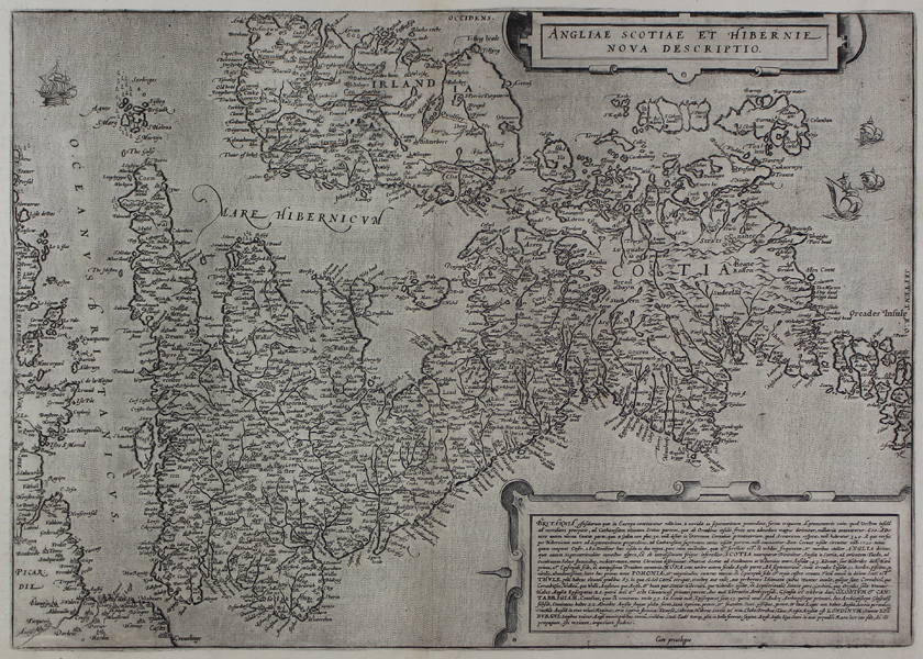
| Artist | de Jode, Gerard |
| Published | Cum privilegio. [Heredu Gerardi de Judaeis. Antwerp, 1593] |
| Dimensions | 350 x 496 mm |
| Notes |
The third and final printing of de Jode's rare map of the British Isles, published by his son Cornelius in the posthumous 1593 edition of the Speculum Orbis Terrae. The plate was first published by de Jode in 1570, likely in response to the publication in the same year of that of his major, and ultimately more successful, competitor, Abraham Ortelius. Both maps were ultimately copies of Mercator's 1564 map of the British Isles, though Ortelius' proved by far the most commercially successful, and where the Ortelius map appeared in over 30 imprints between 1570 and 1612, de Jode's made only three: the first in 1570, the second, featuring text on the verso in 1578, and the third and final printing, also with text on the verso but featuring a folio number '32', in 1593. Gerard de Jode (1509-1591) was a Dutch mapmaker, geographer, engraver, and bookseller, active in Antwerp in the second half of the sixteenth century. His major achievement was the Speculum Orbis Terrarum (Mirror of the Globe), intended as an answer to the Theatrum Orbis Terrarum of his major rival Abraham Ortelius. Despite his skills as an engraver, the beauty and detail of his maps, and his seniority over his younger competitor, the Speculum was a commercial failure. Following Gerard's death, the atlas was printed once more by his son Cornelis in 1593, before the plates were sold upon the latter's death in 1600 to Jan Baptist Vrients. Shirley 173 Condition: Excellent rich impression. Pressed central vertical fold as issued. Manuscript underlining to a number of place names in Ireland, the south of England, and 'Argadia' in Scotland. |
| Framing | mounted |
| Price | £2,200.00 |
| Stock ID | 45444 |