
| Method | Copper engraved with hand colour |
| Artist | Ortelius, Abraham |
| Published | 1573 Cum Privilegio [Antwerp, 1595] |
| Dimensions | 380 x 470 mm |
| Notes |
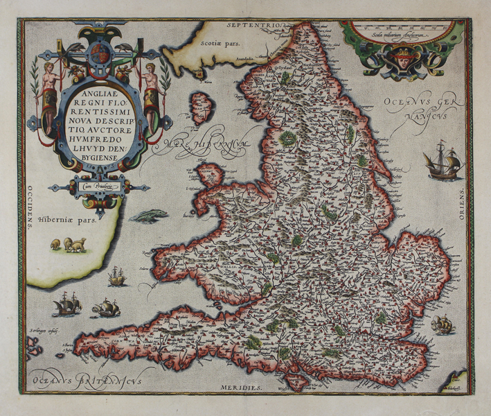
A beautiful and highly decorative map of England and Wales, from the 1595 Latin edition of Ortelius' famous Theatrum Orbis Terrarum. Cartographically, the map follows the 1568 survey of Wales by Humphrey Lluyd, as well as Mercator's 1564 eight-sheet map of the British Isles. Cities, towns, and villages are extensively plotted, and picked out in red, while forests and mountains are highlighted with hand colour. The seas surrounding the British Isles are populated by sailing ships and sea monsters, and a flock of sheep are included in the largely unmapped Ireland. The map is further embellished by a pair of large strapwork cartouches. One, containing the title and privilege, also features the royal crest, flanked by herons and a pair of figures holding laurel staves. The other, in the top right corner, contains the scale in English miles. Abraham Ortelius (1527 -1598) was a Flemish cartographer, cosmographer, geographer and publisher and a contemporary of Gerard Mercator, with whom he travelled through Italy and France. Although it is Mercator who first used the word "Atlas" as a name for a collection of maps, it is Ortelius who is remembered as the creator of the first modern atlas. Theatrum Orbis Terrarum was the first systematically collated set of maps by different map makers in a uniform format. Three Latin editions as well as a Dutch, French and German edition of Theatrum Orbis Terrarum were published by 1572 and a further 25 editions printed before Ortelius' death in 1598. Several more were subsequently printed until around 1612. Ortelius is said to have been the first person to pose the question of the continents once being a single land mass before separating into their current positions. Condition: Central vertical fold as issued. Repaired tear to right of bottom margin, not affecting map or plate. Centre fold reinforced on verso. Latin text on verso. Old manuscript annotations to verso text. |
| Framing | unmounted |
| Price | £900.00 |
| Stock ID | 46172 |