
| Method | |
| Artist | Gastaldi, Giacomo |
| Published | In Venetia, per Gioa. Baptista Pedrezano. Co'l privilegio dell'Illustriß. Senato Veneto per Anni X. M.D.XLVIII [Venice, 1548] |
| Dimensions | 130 x 175 mm |
| Notes |
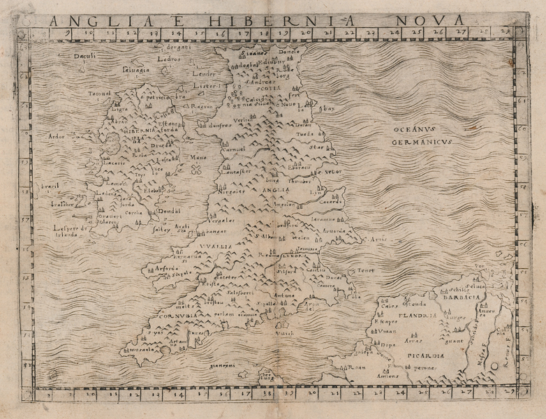
One of the most important, early, and rare maps of the British Isles, from Giacomo Gastaldi's first and only edition of Ptolemy's Geography. This particular map, one of two of the British Isles included by Gastaldi, presents a 'modern' rather than Ptolemaic model of Great Britain and Ireland, as well as adjoining parts of the continental mainland. Gastaldi's 'La Geografia di Claudio Ptolemeo Alessandrino' has been hailed as one of the most significant cartographical achievements of the sixteenth century. Printed in 1548, with maps largely based on Munster and Waldseemuller, the atlas established Gastaldi's primacy amongst Italian geographers, and was also instrumental for two innovations, namely the use of copper plates rather than woodcut blocks for its maps, and its small size, making it in effect the first 'pocket' atlas. Although it only appeared in one edition, it was repeatedly replicated by other Italian cartographers for a century after its first appearance. Giacomo Gastaldi (c.1500-1566) was an Italian geographer, astronomer, and engineer, best known for his landmark edition of Ptolemy's Geography. Ptolemy (c. AD 100-170) was a Greek native of the Egyptian city of Alexandria, and a Roman citizen. Little is known about his life, but he is credited as the author of numerous works of mathematics, engineering, astronomy, astrology, philosophy, and geography. His most famous works were the Almagest, the Geography, and the Tetrabiblion, a triad that essentially formed the basis of Byzantine, Arabic, and European science for the next thousand years. The Geography in particular had a very long reach, being reprinted numerous times in the fifteenth and sixteenth centuries. Its most famous advocate was Columbus, who used a manuscript of the Geography to plot his western course for Asia, in the journey that resulted in the discovery of America. The work was also a major inspiration, and cartographic resource, for Munster, Mercator, and Ortelius. Shirley 48 Condition: Central vertical fold, as issued. Time toning to central fold with repair at base. Minor creasing and staining to margins. Italian text on verso. |
| Framing | mounted |
| Price | £900.00 |
| Stock ID | 51987 |