
| Method | Copper engraved |
| Artist | Boisseau, Jean |
| Published | [Paris, I. Boisseau 1643] |
| Dimensions | 130 x 175 mm |
| Notes |
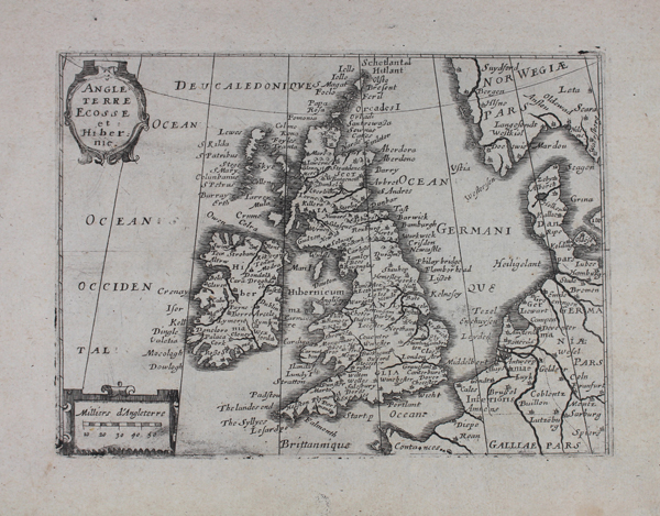
A rare and unusual variant, or possibly a pirated copy, of Jean Boisseau's first small-scale French map of the British Isles, derived from the Jansson Atlas Minor 'Anglia Regnum' and published in the 1643 edition of the 'Tresor des Cartes Geographiques des principaux estatz de l'univers.' The map lacks the expected folio number '6' in the bottom right corner of the plate, and the cartouches are relatively poorly engraved, suggesting this is either a preliminary printing, a later reworking, or a direct forgery. Cartographically, Shirley describes the map as 'undistinguished.' Despite the French title and scale in 'milliers d'Angleterre,' the map retains Jansson's latin titles for states and kingdoms, but individual cities and place names are in English. The seas surrounding the British Isles are labelled in French. Strapwork cartouches containing the title and scale are provided at top and bottom left, and the border is broken into increments that are as yet unlabelled and unshaded. Jean Boisseau (fl. 1637-1657) was a Parisian mapmaker and publisher. His 'Trésor des Cartes Geographiques' was one of the first original French world atlases, based largely on the maps of Jansson's edition of the Mercator-Hondius 'Atlas Minor'. Boisseau's maps were also included in a composite text compiled for the education of the young future King Louis XIV, as well as being reprinted in several editions by Louis Boissevin, Nicolas Picard, Claude Jollain, Pierre du Val and others. Condition: Minor time toning to edges of sheet, not affecting plate or map. Blank on verso. |
| Framing | unmounted |
| Price | £400.00 |
| Stock ID | 46182 |