
| Method | Copper engraved with hand colour |
| Artist | Georg Braun and Frans Hogenberg |
| Published | [Cologne, c.1572] |
| Dimensions | 337 x 485 mm |
| Notes |
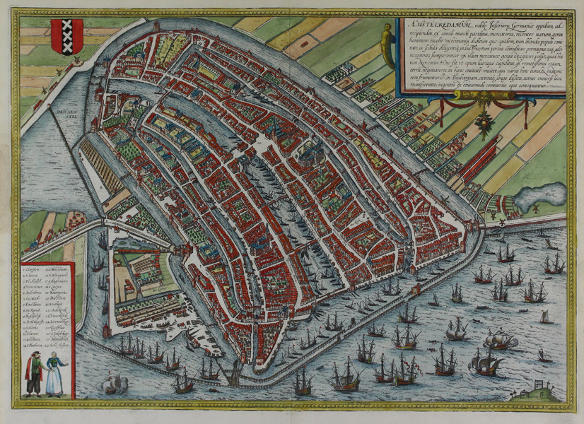
A birds-eye map of Amsterdam, from the first volume of Braun and Hogenberg's Civitates Orbis Terrarum. The city is viewed with north at the bottom of the sheet, with the Amstel river entering the city from the top left corner of the map. On the waterfront, a plenitude of sailing vessels of all sizes lie at anchor or approach and depart the famous merchant city. In the bottom right corner, a numbered key is embellished with an illustration of Dutch national costume, and the crest of the city is included above. The map was originally engraved for the first volume of the Civitates Orbis Terrarum following the 1544 town plan by Cornelis Anthonisz, and despite being superseded by a more up to date example in the sixth volume, continued to be published along side it. Between 1572 and 1617 Georg Braun (1541-1622) and Frans Hogenberg (1535-1590) published six volumes of their Civitates Orbis Terrarum, containing over 500 prospects, views, and maps of mostly European cities, envisioned as a companion to Ortelius' atlas Theatrum Orbis Terrarum. Braun was the editor of the series, with Hogenberg as principle engraver. They relied mainly on existing cartography, but also on drawings made by the Antwerp artist Joris Hoefnagel (1542-1600), who had travelled through most of Western Europe. After Joris Hoefnagel's death his son Jakob continued the work for the Civitates. Condition: Central vertical fold as issued. Some staining and tear repairs to margins, not affecting map. French text on verso. |
| Framing | unmounted |
| Price | £1,400.00 |
| Stock ID | 46779 |