
| Method | Copper engraving |
| Artist | Johannes Blaeu |
| Published | se vend A Amsterdam Par Pierre Mortier Avec Privil. [1704-5] |
| Dimensions | Image 378 x 493 mm, Plate 383 x 499 mm, Sheet 512 x 634 mm |
| Notes |
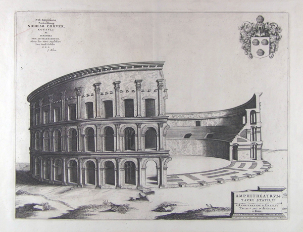
An architectural study of the Amphitheatre of Statilius Taurus, originally erected on the Campus Martius in Rome. Built in 29 BC, the amphitheatre was completely destroyed in 64 AD during the Great Fire of Rome. In this depiction, a section of the amphitheatre is removed, allowing for a view of the interior, and construction details of the façade. A coat of arms is featured in the upper right corner of the plate, and in the lower right corner, the title is inscribed in Latin and French, along with publication details, upon a plinth. Inscription in upper left corner: 'Nob: Amplißimo / Prudentißimoqs / Nicolao Corver, / Consuli / ac / Senatori / Reip. Amstelædamensis, / Novum hanc veteris Amphitehatri / Tauri Statilii Tabulam / D. D. D. / J. Blaeu.' This engraving was originally published in Johannes Blaeu's 'Theatrum civitatum et admirandorum Italiae' in 1663. The two volume publication featured 119 engraved plates illustrating Italian views, plans, monuments, and sculptures, with the second volume being dedicated to Ancient Rome. In a preliminary edition, a third volume relating to Naples and Sicily was issued. Blaeu's publication proved to be extremely popular, and was therefore reissued several times by various publishers in Amsterdam until 1726. This particular impression belongs to Pierre Mortier's edition. Between 1704 and 1705, Mortier reissued the plates in a four volume edition. Pieter Mortier (1661–1711) was an 18th-century mapmaker and engraver from the Northern Netherlands. Mortier was born in Leiden. According to Houbraken, David van der Plas worked with him on etchings for Bybelsche Tafereelen (Bible stories), published in Amsterdam in 1700. He was the father of Cornelis Mortier (1699-1783), who in partnership with Johannes Covens I (1697-1774) began the map publishing company Covens & Mortier (1721-1866). He travelled to Paris in 1681-1685 and won the privilege in 1690 of publishing maps and atlases by French publishers in Amsterdam. He used this privilege to win a similar set of privileges for printing an "illustrated print bible" in 1700. He died in Amsterdam. The Blaeu family were one of the most famous publishers of maps, globes and atlases during the seventeenth-century. Cartographers, globe makers and booksellers, the Blaeu business flourished in Amsterdam for over 40 years, until a fire destroyed their premises in 1672. They lost all of their plates, prints and stock, which effectively ruined the firm. Willem Blaeu founded the business in 1596. It initially functioned as a globe and instrument makers, but soon expanded into maps, topography and sea charts. The Atlas Novus was Willems great work; a major work which intended to include the most up-to-date maps of the entire world. He issued the first two volumes in 1635, but died in 1638 before the atlas was completed. The running of the business was passed on to his sons Johannes and Cornelius, in addition to the role of the official cartographer of the East India Company. After the death of Cornelis in 1644, Johannes continued the business alone and established his own reputation as a great mapmaker. Johannes completed his father's grand project in 1655 with the sixth and final volume of the Atlas Novus. He also produced the Tooneel der Steden van der Vereenighde Nederlanden in 1649-1653, as well as a similar set of Italian town plans which were published in 1663. Condition: Vertical centre fold as issued, and some light creasing to margins. A red line is present in the upper left corner of the plate, encroaching into inscription. |
| Framing | unmounted |
| Price | £350.00 |
| Stock ID | 41039 |