
| Method | Copper engraved |
| Artist | Ortelius, Abraham |
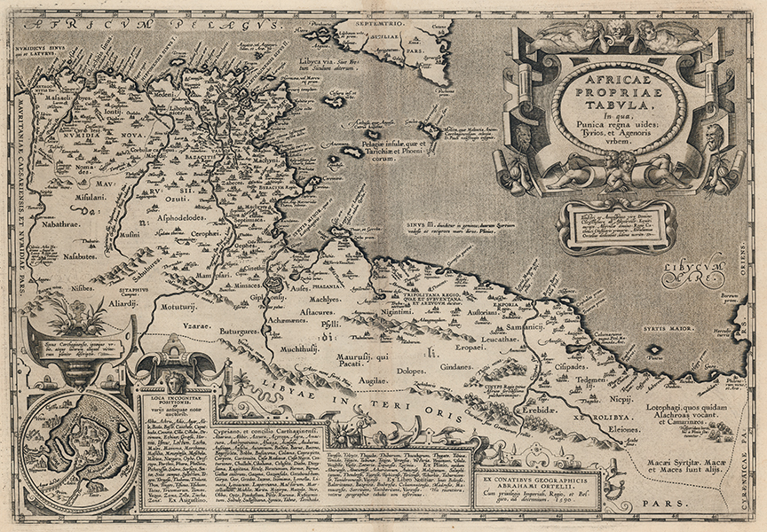
| Published | Ex conatibus geographicis Abrahami Ortelii. cum privilegio Imperiali, Regio, et Belgico, ad decennium. 1590. [Antwerp, 1595] |
| Dimensions | 333 x 485 mm |
| Notes |
A map of ancient North Africa, from the 1595 Latin Parergon (Supplement) of Ortelius' famous Theatrum Orbis Terrarum. The map depicts the extent of the Roman Province of Africa, roughly contiguous with modern day Libya and Tunisia, as well as parts of the neighbouring provinces of Mauretania Caesariensis, Numidia, Cyrenaica, and the southern half of Sicily. Principal cities and towns are plotted with their ancient placenames, and the map is heavily annotated with references from the classical source tradition for the various cities, settlements, and myths of North African antiquity. The famously dangerous shallows of Syrtis are marked off the coast of Tripolitana, and the domain of the mythical Lotus-Eaters from Homer's Odyssey is plotted on the borders of Cyrenaica, close by a forest representing Pliny's putative location for the paradisiacal Garden of the Hesperides. In the pre-Roman period, the North African coast was largely controlled by the maritime and commercial empire of the city of Carthage, and the map is described as a 'proper' representation of the Punic kingdom and the city of Agenor, the mythic ruler of Tyre and father of the Phoenician people. Ortelius' depiction of the region is historically and chronologically nuanced, overlaying the various tribes, nations, and empires that occupied the area, including nomadic Berber tribes, Carthaginian and Greek trading cities, Roman administrative divisions, and even the Vandals, who invaded under their leader Geiseric and seized Carthage from the Byzantines in the fifth century AD. Further notes add details about St Paul's shipwreck off the coast of Malta, the naming of the city of Zama where Scipio Africanus defeated Hannibal, and the mythical Lake Tritonis and its islands. The map is further embellished by a pair of decorative cartouches. The first, enclosed by decorative strap-work and cupids, encloses the title and dedication. The second, much larger, cartouche at the bottom of the plate includes a three columned list of place names of uncertain location as well as a circular inset map of the walled harbour of Carthage and the nearby cities of Tunis and Utica. Adorning the strap-work on both cartouches are numerous examples of the region's ancient prosperity, most ubiquitous being the famous Punic figs that the Roman orator Cato the Elder used to great effect in his speeches exhorting the destruction of Carthage. On the verso, copious Latin text describes the history and culture of the region, particularly the city of Carthage itself. The end-piece for the text is made up of four examples of ancient coinage. The Parergon ('Supplement') was, as the title suggests, originally conceived of as a supplement to Ortelius' Theatrum. The work, a massive and intricately researched index of the classical world, was accompanied by a series of ancient world maps. Unlike the maps of the Theatrum, the majority of which were reductions of earlier maps, the maps of the Parergon were researched and drawn by Ortelius himself. The work was a huge commercial success, and the maps themselves set the standard for ancient world maps for the duration of the seventeenth century, being reproduced or reprinted by various publishers after Ortelius' final 1624 printing. His interest in the mapping of the ancient world is manifest. The maps of the Parergon are a veritable mine of textual commentary and classical philology, drawing upon Ptolemy, Strabo, Pliny, and many others. Interestingly, the project seems to have been a labour of love, rather than a mercantile venture. Ortelius himself was fascinated with the ancient world, and a formidable classical scholar in his own right. In addition to his work as a cartographer, he dealt in antiquities, visited and surveyed ancient sites across Europe, published a critical edition of Caesar's Gallic Wars in 1593, and assisted Welser in his studies of the famous Tabula Peutingeriana in 1598, producing an engraved copy of the map that can be found in later editions of the Parergon. Abraham Ortelius (1527 -1598) was a Flemish cartographer, cosmographer, geographer and publisher and a contemporary of Gerard Mercator, with whom he travelled through Italy and France. Although it is Mercator who first used the word "Atlas" as a name for a collection of maps, it is Ortelius who is remembered as the creator of the first modern atlas. Theatrum Orbis Terrarum was the first systematically collated set of maps by different map makers in a uniform format. Three Latin editions as well as a Dutch, French and German edition of Theatrum Orbis Terrarum were published by 1572 and a further 25 editions printed before Ortelius' death in 1598. Several more were subsequently printed until around 1612. Ortelius is said to have been the first person to pose the question of the continents once being a single land mass before separating into their current positions. Condition: Central vertical fold as issued. Minor time toning to central fold. Tear to bottom margin, not affecting map. Old adhesive stains to top corners of verso. Latin letterpress text on verso. |
| Framing | |
| Price | £750.00 |
| Stock ID | 53135 |