
| Method | Copper engraved |
| Artist | Ortelius, Abraham |
| Published | Ex conatibus Geographicis Abrahami Ortelij Antwerp. Cum privilegio Imperatorio, Regio, et Cancellariae Brabantiae, decennali. 1594. [1624 Parergon edition] |
| Dimensions | 345 x 490 mm |
| Notes |
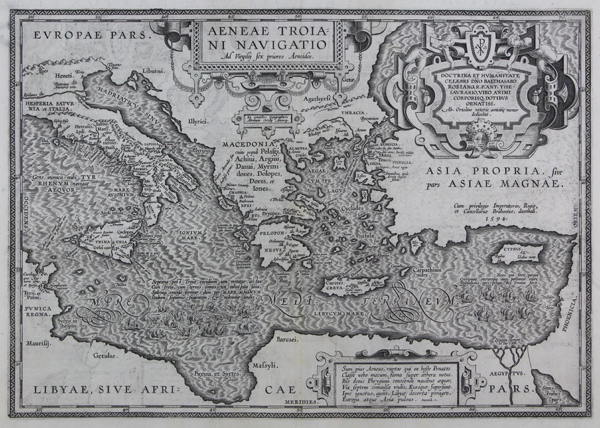
A superb map of the wanderings of Aeneas, the Trojan hero and ancestor of the Roman people, from the 1624 Parergon (Supplement) of Ortelius' famous Theatrum Orbis Terrarum. The map depicts the journeys of Aeneas and his band of Trojan exiles across the Eastern Mediterranean. The map is heavily annotated with information and verses gleaned from Virgil's Aeneid, listing all of the locations mentioned in the text, as well as the various tribes, peoples, and nations of the Greek, Trojan, North African, and Latin worlds. Principal cities and towns are listed, and many of them are provided with further anecdotes and explanations. In the sea itself, two groups of warships are depicted. One, off the coasts of North Africa and Sicily, depicts a scene of ship-wreck. A number of the epic poem's more fantastic elements are also featured on the map, including the Cyclopes, included amongst the inhabitants of Sicily, the monster Scylla at the straits of Messina, and the rocks of the Sirens off the coast of Naples. The map is further embellished by three decorative strap cartouches, one enclosing the title, another with a dedication to Balthasar Robiano surmounted by a chi-rho and alpha-omega, and the third featuring a passage from Aeneid 1, describing Aeneas' journey with his ancestral gods, and the seven ships remaining to him after his tumultuous voyage. On the verso, in addition to a lengthy description of the geography of the Mediterranean in reference to the Voyages of Aeneas, is a depiction of Roman coinage in bronze and silver, depicting figures from early Roman history and myth. These include the Roman Eagle, the She-wolf with the infant twins Romulus and Remus, Aeneas carrying the Penates and the aged Anchises, as well as personifications of Roma and Italia. The Parergon ('Supplement') was, as the title suggests, originally conceived of as a supplement to Ortelius' Theatrum. The work, a massive and intricately researched index of the classical world, was accompanied by a series of ancient world maps. Unlike the maps of the Theatrum, the majority of which were reductions of earlier maps, the maps of the Parergon were researched and drawn by Ortelius himself. The work was a huge commercial success, and the maps themselves set the standard for ancient world maps for the duration of the seventeenth century, being reproduced or reprinted by various publishers after Ortelius' final 1624 printing. His interest in the mapping of the ancient world is manifest. The maps of the Parergon are a veritable mine of textual commentary and classical philology, drawing upon Ptolemy, Strabo, Pliny, and many others. Interestingly, the project seems to have been a labour of love, rather than a mercantile venture. Ortelius himself was fascinated with the ancient world, and a formidable classical scholar in his own right. In addition to his work as a cartographer, he dealt in antiquities, visited and surveyed ancient sites across Europe, published a critical edition of Caesar's Gallic Wars in 1593, and assisted Welser in his studies of the famous Tabula Peutingeriana in 1598, producing an engraved copy of the map that can be found in later editions of the Parergon. Abraham Ortelius (1527 -1598) was a Flemish cartographer, cosmographer, geographer and publisher and a contemporary of Gerard Mercator, with whom he travelled through Italy and France. Although it is Mercator who first used the word "Atlas" as a name for a collection of maps, it is Ortelius who is remembered as the creator of the first modern atlas. Theatrum Orbis Terrarum was the first systematically collated set of maps by different map makers in a uniform format. Three Latin editions as well as a Dutch, French and German edition of Theatrum Orbis Terrarum were published by 1572 and a further 25 editions printed before Ortelius' death in 1598. Several more were subsequently printed until around 1612. Ortelius is said to have been the first person to pose the question of the continents once being a single land mass before separating into their current positions. Condition: Strong, dark impression with full margins. Central vertical fold as issued. Minor offsetting to top left of plate. Minor time toning to top margin, not affecting plate or map. Latin text on verso. |
| Framing | framed |
| Price | £1,250.00 |
| Stock ID | 44500 |