
| Method | Copper engraved |
| Artist | Rocque, John |
| Published | at Charing Cross 1750. Publish'd According to Act of Parlaiment |
| Dimensions | 480 x 700 mm |
| Notes |
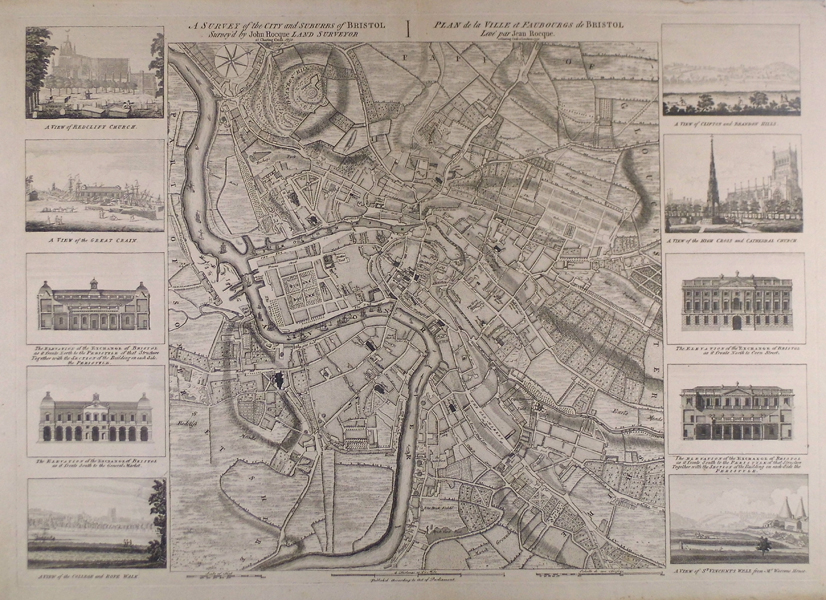
A fine and detailed, separately published, map of the city and suburbs of Bristol. The map was surveyed, drawn and published by John Rocque and is flanked by 10 views of public buildings and local topography: A view of Redcliff Church on the south side with part of church yard - A view of the Great Crain and Slip at the lower end of Princess Street - The elevation of the Exchange of Bristol as it fronts north to the Peristyle... - The elevation of the Exchange of Bristol as it fronts to the General Market ... - Cathedral or the view of the college and rope walk from the opposite south side of the River Avon - A view of Clifton and Brandon Hills from the south side of the River Avon - A view of the High Cross and Cathedral Church from the north side of College Green - The elevation of the Exchange of Bristol as it fronts north to Corn Street - The elevation of the Exchange of Bristol as it fronts south to the Peristyle - A view of St. Vincents Rocks with the Hot Well's from Mr Warrens House. This detailed city plan is a single-sheet reduction of Rocque's 1743 four sheet map of Bristol. It plots the all the major roads, buildings, and landmarks from Redclift (Redcliff) to King's Down (Kingsdown) with the Rivers Avon and Froom (Frome) snaking through the city and littered with sailing and merchant vessels. Brandon Hill occupies the top left corner of the map with relief shown by hachures. The map is plainly titled in English and French and has three measurement scales below, a compass rose to the top left indicates the unusual orientation of north to the top right. John Rocque (1709-1762) was a Hugenot refugee who came to England as a baby in 1709 with his parents, fleeing persecution in France. In addition to his work as surveyor and mapmaker, Rocque was an engraver and map-seller. He was also involved in gardening as a young man, living with his brother Bartholomew, who was a landscape gardener, and producing plans for parterres, perhaps recording pre-existing designs, but few details of this work are known. Rocque produced engraved plans of the gardens at Wrest Park (1735), Claremont (1738), Charles Hamilton's naturalistic landscape garden at Painshill Park, Surrey (1744), Wanstead House (1745) and Wilton House (1746). Rocque is now mainly remembered for his Map of London, published in twenty four sheets in 1746. It was by far the most detailed map of London published up to that time, and remains the most detailed map of eighteenth century London today. Rocque also published another smaller-scale map of London in sixteen sheets at the same time. His success as a cartographer brought him the appointment as cartographer to Frederick, Prince of Wales in 1751. A fire in 1750 destroyed his premises and stock, but by 1753 he was employing ten draughtsmen, and published The Small British Atlas: Being a New set of Maps of all the Counties of England and Wales. Rocque's 1756 map of Dublin featured on an Irish ten pound bank note. He married twice. His widow continued the business after his death. Map Forum Issue 5, The Works of John Rocque #50. Condition: Good clean impression, well pressed light centre fold. Two very small worm holes to centre of map and one to view of the Exchange. |
| Framing | mounted |
| Price | £2,500.00 |
| Stock ID | 42271 |