
| Method | Copper engraved |
| Artist | Baker, Benjamin |
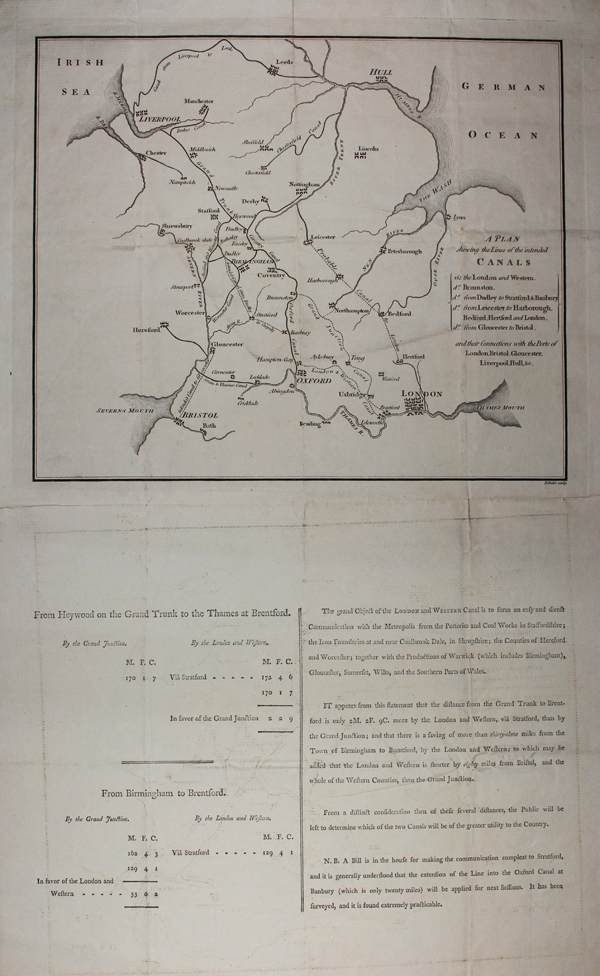
| Published | B. Baker sculp. [London, c.1790] |
| Dimensions | 210 x 250 mm |
| Notes |
A rare map of England's canal network as it was at the end of the eighteenth century, with planned extensions between London and Leicester, London and Oxford, Birmingham and Banbury, and Gloucester and Bristol. The map was likely separately published, as it appears on an inventory of numerous other canal charts and planning documents that were included in the cartographic collection of George III, which were eventually presented to the British Museum. The letterpress text below the map explains that the putative new network is intended to connect London to the Potteries and Coal Works of Staffordshire, the foundries of Shropshire, the manufacturies of Birmingham and Warwickshire generally, and to provide better access to Hereford, Worcester, Gloucester, Bristol, Liverpool, and Hull. Benjamin Baker (1766-1841) was a mapmaker and publisher, best known as the lead engraver of the Ordinance Survey, a position he held from 1804, though he also produced maps both general and specialist for a number of publishers and projects. Condition: Pressed vertical and horizontal folds. Creasing, minor chipping, and time toning to edges of sheet. Letterpress text below map. Blank on verso |
| Framing | unmounted |
| Price | £375.00 |
| Stock ID | 48359 |