
| Method | Copper engraved |
| Artist | Stockdale, John |
| Published | Published by I. Stockdale Piccadilly, 1800. |
| Dimensions | 180 x 260 mm |
| Notes |
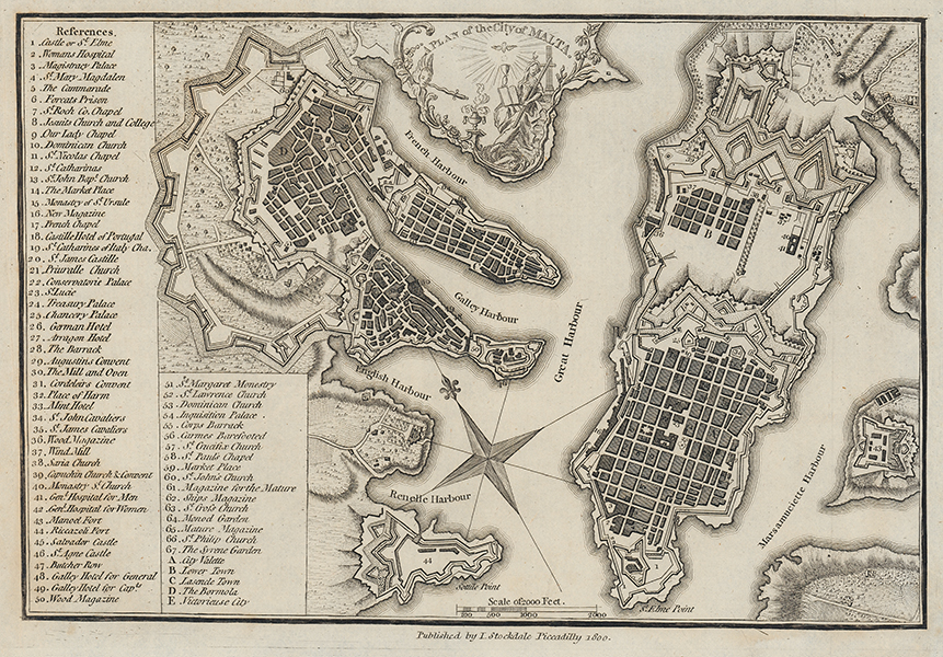
A detailed town plan of Valetta and surrounds, originally issued in 1772 by Andrews in 'A Collection of Plans of the Most Capital Cities of every Empire, Kingdom, Republic and Electorate in Europe and some Remarkable Cities in the other Three Parts of the World.' The current example was reissued by Stockdale in 1800 in 'A Geographical, Historical, and Political Description of the Empire of Germany, Holland, the Netherlands, Switzerland, Prussia, Italy, Sicily, Corsica, and Sardinia.' The map is centred on the Great Harbour, with the famous grid plan of Valetta shown on the promontory. Along the left hand side of the map, a very large numerical key lists 67 points of interest, as well as the five districts within the city's walls. On another promontory above the French harbour, the title of the map is emblazoned, above a baroque vignette of allegorical figures. John Stockdale (1749 - 1814) was a book and print publisher. Between 1780 and 1781 he worked for the radical publisher John Almon, then on his own account in Piccadilly. In 1788 he was indicted, unsuccessfully, for libel after publishing John Logan's Review of the Charges Against Warren Hastings. His business was carried on after his death by his son John Joseph. Condition: Minor time toning and foxing to margins. Blank on verso. |
| Framing | unmounted |
| Price | £250.00 |
| Stock ID | 53479 |