
| Method | Copper engraved |
| Artist | Stockdale, John |
| Published | Published by J. Stockdale Piccadilly, 1800. |
| Dimensions | 180 x 240 mm |
| Notes |
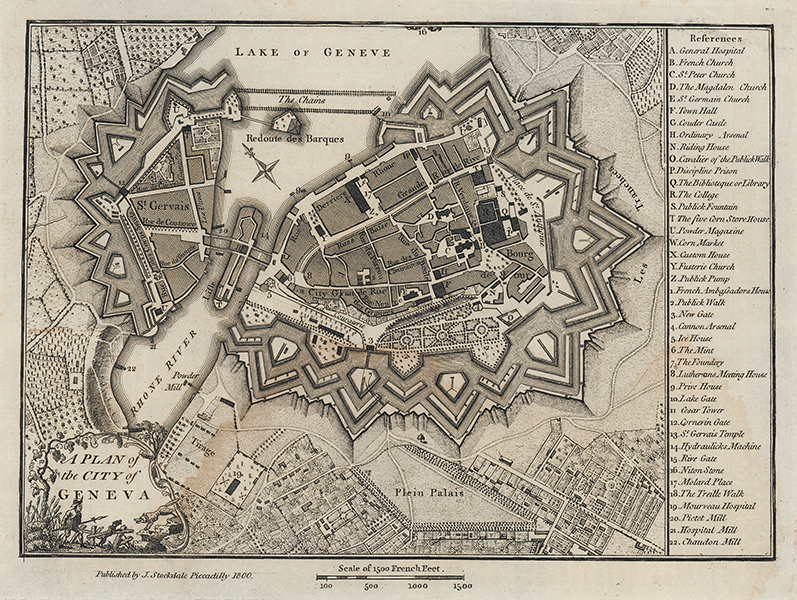
A detailed town plan of Geneva, originally issued in 1772 by Andrews in 'A Collection of Plans of the Most Capital Cities of every Empire, Kingdom, Republic and Electorate in Europe and some Remarkable Cities in the other Three Parts of the World.' The current example was reissued by Stockdale in 1800 in 'A Geographical, Historical, and Political Description of the Empire of Germany, Holland, the Netherlands, Switzerland, Prussia, Italy, Sicily, Corsica, and Sardinia.' The map is centred on the city, with its impressive defensive walls. Crossing the mouth of the Rhone where it opens onto Lake Geneva, a pair of giant chains cross the waterway to St Gervais. Along the right hand side of the map, a very large key lists 42 points of interest. The title is enclosed by a vignette in the bottom left featuring a rustic and his dog fighting a wolf. John Stockdale (1749 - 1814) was a book and print publisher. Between 1780 and 1781 he worked for the radical publisher John Almon, then on his own account in Piccadilly. In 1788 he was indicted, unsuccessfully, for libel after publishing John Logan's Review of the Charges Against Warren Hastings. His business was carried on after his death by his son John Joseph. Condition: Large waterstain to lower half of page. Minor creasing to corners. Blank on verso. |
| Framing | unmounted |
| Price | £125.00 |
| Stock ID | 53480 |